Here’s video from a recent IFR proficiency flight from Boeing Field (KBFI) to Arlington, WA (KAWO). After a departure in IMC, I flew the RNAV RWY 34 approach to LPV minimums at KAWO, using the GFC 600 autopilot for the approach and the TOGA feature for a coupled missed approach.
Notice the glory as I cruise just above a solid cloud deck with the sun at my back.
This video also shows my use of cockpit and avionics flows followed by checklists to prepare for an approach.
For more information about those techniques, see the following videos:
To learn more about how I set up the displays in my panel and in ForeFlight on my iPad, see “Sipping Information from the Right Glass,” my IFR Tip in the December 2023 issue of AOPA Pilot magazine (you may need an AOPA membership to read the full article).
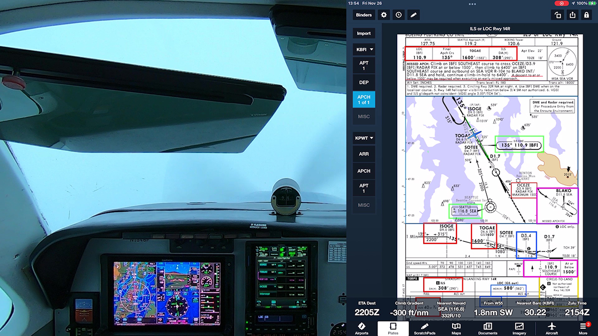
Boeing Field management contracted with Hughes Aerospace Corporation to develop these approaches, but they are public use, and the charts appear in the databases in EFBs and panel avionics.
Note that these are not Authorization Required (AR) approaches (for more information about that topic, see Unscrambling RNAV, RNP, and Other Chart Naming Conventions and Notes). The new approach to runway 14R replaces the old RNAV (GPS) Y procedure, and it’s a welcome supplement to the ILS RWY 14R, which is often out of service.
Both approaches offer LPV minimums for WAAS-equipped aircraft.
Here are detailed views of the new RNAV (GPS) RWY 14R approach, which features tracks through Elliott Bay, keeping low-altitude traffic (and noise) away from the Magnolia neighborhood. I transferred information from the approach chart to VFR charts (at SkyVector). The positions of the fixes and the tracks are approximate, but they help you visualize the new flight paths. (For similar views of the new RNAV (GPS) RWY 32L approach, scroll down.)
Here are views of the fixes in the new RNAV (GPS) RWY 32L approach.
Sometimes just one cloud gets in the way when you’re flying an instrument approach.
In this video, I fly the RNAV (GPS) RWY 35 approach at Olympia, WA (KOLM), southwest of Seattle. Although the weather was mostly good VMC, and the Olympia airport was operating under VFR during my flight, as you’ll see, I had to go missed on the approach when I reached the MDA on this LNAV-only procedure because just one cloud blocked the view of the runway.
Because I have a WAAS-capable Garmin GTN 750Xi in the panel, I almost always have at least advisory vertical guidance when I fly an approach. The GTN shows +V to indicate an advisory descent path when you load a procedure like the RNAV (GPS) RWY 35. That capability lets me fly almost all approaches using the same profile and aircraft configuration that I use for an ILS or RNAV approach with LPV minimums.
On this day, had I intended to land, I could have leveled off at the MDA and continued toward the published missed approach point, and I probably would have been in the clear before I reached the threshold. But that strategy might have left me too high to make a smooth, stable descent to the runway. Indeed, on this day, with the airport itself essentially in the clear, had I really wanted to land, I could have canceled IFR well out along the final approach course and followed the tower’s instructions to enter a VFR traffic pattern.
But in actual IMC or marginal VMC, when I descend using an advisory +V glidepath, I use the point at which I reach the MDA as the missed approach decision point. By design, the intersection of the advisory glidepath and MDA typically puts you close the charted visual descent point (if a VDP is available). That’s the point at which you can leave the MDA and continue to the runway in a stable, normal descent.
This approach also helps illustrate another useful technique. As you’ll hear, I told the approach controller that I could accept vectors to the final approach course instead of flying a feeder route or course reversal. But as that plan came together, I didn’t use the VTF option in the GTN.
Instead, I selected CETRA, an IF, as the transition when I loaded the approach. Then I activated the leg of the procedure that ends at the FAF, CORER. The GTN drew a magenta line extending out from the FAF that I could use a reference as ATC vectored me to join the final approach course.
That technique avoids what I call the “vectors-to-final scramble.” Selecting an appropriate initial fix and then activating a leg or proceeding direct to a fix below the procedure title both activates the approach and preserves your options should ATC need to change the plan or, if you go missed and want to give the approach another try.
Most of us understand how paired LOC and GS signals provide a course and a glideslope to follow when flying an ILS to a decision altitude (DA). (If you’d like a detailed review, see, for example, How ILS Works on the FlightInsight YouTube channel).
But the glidepath you see when flying an RNAV (GPS) approach to LPV minimums (usually shown as a magenta diamond on the vertical deviation scale) is more mysterious.
To make an LPV mimic an ILS’s behavior, LPV relies on programmed coordinates and instructions contained in a Final Approach Segment (FAS) data block. The FAS data block contains instructions for the approach, including coordinates for the runway, threshold crossing height, elevation, glidepath angle, and horizontal and vertical alert limits. The GPS receiver computes both linear and angular deviation but, as previously mentioned, only angular is displayed. They can be thought of as instructions to provide a pseudo localizer and glideslope.
In other words, the IFR-approved navigation receiver in your panel receives GPS-WAAS signals from space, and then creates a glidepath. The GP that you see and your AP/FD follows doesn’t emanate from a transmitter on the ground. That’s one reason we have so many RNAV (GPS) approaches with LPV minimums, even at small, quiet airports. Except for runway lights and (optional) approach lights, an approach with LPV minimums that mimics an ILS does not require expensive transmitters on the ground.
You GPS-WAAS receiver uses the same principles to create the advisory glidepaths (e.g., LNAV+V and LP+V) that you can use to help you descend to the MDA when flying a 2D (non-precision) approach, or to fly the vertical guidance on the visual approaches available with the latest GPS navigators.
A warm front recently brought widespread IMC to the Seattle area, and because the freezing level had climbed to about 5000 ft., I had a good opportunity to fly a couple of approaches for practice.
Ride along as I hop from Boeing Field (KBFI) in Seattle to nearby Bremerton National (KPWT), just across Puget Sound, for an RNAV (GPS) approach with a ceiling that was just 100 ft above the published DA of 200 ft. I let the GFC 600 autopilot fly the approach–my standard operating procedure when the weather is near minimums–so that I could could make sure that the airplane and avionics were properly set up. The GFC 600 also can fly a coupled missed approach, as you’ll see.
To learn more about how I prepare for IFR flights, see:
As the video below shows, I spent most of the flight in the clouds, but the tops in the area were at about 3500 ft., and I was able to cloud surf in an interesting sky for a little while.
Note that I filed three-letter codes in the remarks section of my flight plan to help Seattle Approach Control anticipate the procedures that I wanted to fly. For an explanation of the codes you can use in the TRACON’s airspace, see this document (PDF).
One of the terrific features available in the latest digital autopilots is VNAV, or vertical navigation. If you have a Garmin GTN-series navigator and a GFC 500 or GFC 600 autopilot, you can use VNAV to descend to the charted altitudes along the intermediate legs of an instrument approach, until you reach the final approach fix.
VNAV is also available on most G1000 systems equipped with the GFC 700 autopilot, including the new G1000 NXi, and some other manufacturers, such as Avidyne, plan to add the feature to their systems.
The 10-minute video below demonstrates how VNAV can help you fly a smooth, precise descent prior to the FAF. The video explains the basic concepts, uses the Garmin PC Trainer Suite to highlight key details, and then shows VNAV at work as I fly the RNAV (GPS) RWY 12 approach at Kelso, WA (KKLS).
For more information about VNAV, see Garmin GTN VNAV here at BruceAir. Garmin has also posted a detailed explanation of VNAV in the following video.
Join me on an IFR flight from Boeing Field (KBFI) in Seattle to Hoquiam (KHQM) on the Washington coast.
I wanted to exercise the Bonanza after an oil change and other maintenance (I had already completed a couple of VFR test flights). The weather was marginal VFR around Seattle, but a typical layer of coastal low clouds and fog shrouded Hoquiam in low IFR conditions, making a good setup for practicing an RNAV approach–the RNAV (GPS) RWY 24–at the normally sleepy KHQM before diverting to Bremerton to top off the fuel tanks.
As you’ll see, however, this flight included a couple of twists, including an ad-hoc hold en route to allow a preceding aircraft to complete its approach. And when I arrived at the DA, about 200 ft above the ground, the reported variable ceiling wasn’t so variable. I had to fly a real missed approach.
If you just want to see the final approach segment, watch the 5 minute clip below. A longer version, showing the departure, en route ad-hoc hold, and the approach appears at the end of this post.
Here’s a potentially provocative statement: Don’t activate approaches.
As I have explained in other posts (list below), with most modern GPS navigators, there’s no need explicitly to activate an approach. Activating an approach isn’t magic–that step simply makes the initial fix (called the “transition” in Garmin and other navigators) the current direct-to waypoint.
Don’t activate approaches
In many–perhaps most–cases, proceeding direct to the initial fix you choose when you load an approach is not what you–or ATC–want the navigator to do, at least right now. ATC may assign vectors to the final approach course or clear you to a different initial fix. In particular, if you activate vectors to final (VTF), the fix you need may no longer be visible and available on the moving map and flight plan page, leading to what I call the vectors-to-final scramble. But loading an approach early, with an appropriate initial fix, gives you time to review and brief the procedure–and to prepare for changes that ATC may make to your best-laid plans.
When you fly an RNAV approach with a GPS navigator, the system performs a series of calculations and internal tests, such as confirming GPS signal accuracy and precision. As you proceed along feeder routes or vectors toward the final approach fix, the navigator also smoothly narrows the course width from en route to terminal to approach scale, and finally it displays the best available minimums for the approach given your system’s capabilities. But from your perspective in the cockpit, an approach–even when you use a GPS to complement a conventional approach such as an ILS–is essentially a sequence of waypoints, like other legs of a flight plan. Understanding that fact and knowing how to work with flight plans are the keys to setting up an approach and confirming that the procedure is progressing as you expect.
To help you practice using its avionics, Garmin offers free PC-based and iOS trainers (simulations) of its navigators:
On the flight plan page, if the active leg or direct-to fix is below the procedure title, the approach is active.
Instead of explicitly activating an approach, follow these steps to load and fly an approach (the same basic technique also works when flying STARS):
Load the procedure you want to fly.
For transition, choose a fix appropriate for the direction from which you’re arriving.
Load, but don’t activate, the approach. Review the procedure. Wait until you confirm that you’ll receive vectors to join a segment of the procedure or until ATC clears you direct to an initial fix.
If ATC vectors you to join a feeder route/transition or the final approach course, activate the appropriate leg of the procedure.
If ATC clears you to a fix, proceed direct to that fix.
This technique also keeps the fixes in the flight plan should you want to fly the approach again after flying a missed approach or if you need more time to configure the airplane or deal with a distraction.
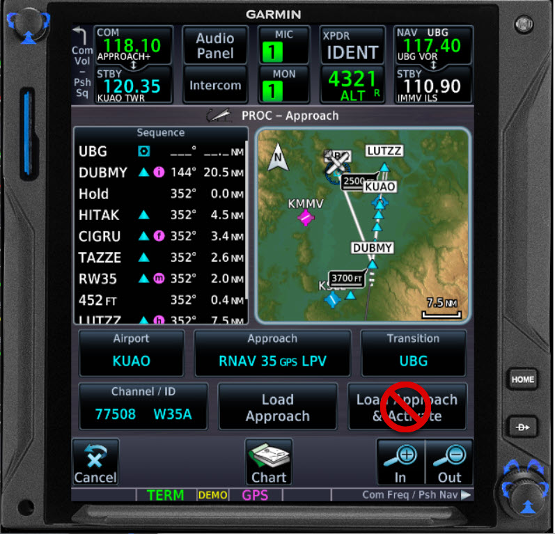
Consider the the RNAV (GPS) Y RWY 4 at Moses Lake, WA (KMWH). If you approach KMWH from the east, choose ONPIC or MWH as the transition. If you arrive from the west, choose EDSEW, RUBEL, or ONPIC.
If ATC provides vectors to join the final approach course between ONPIC and UBGUY (the FAF), activate that leg.
But if ATC clears you to MWH, ONPIC, RUBEL, or EDSEW, you can still easily proceed direct and fly the approach beginning at that new point.
Loading the RNAV RWY 04 Y approach with MWH as the transition (initial fix).
The map view shows all the fixes and the course reversal.
The approach title appears in the flight plan, with the fixes after MWH available.
You can proceed direct to MWH to fly the full procedure. Or, to accept vectors to the final approach course, delete the hold and activate the leg between ONPIC and UBGUY.
If you arrive at KMWH from the west, EDSEW is a logical choice for the transition.
Loading EDSEW keeps other fixes in the flight plan and visible on the map.
If you are cleared and proceed direct to EDSEW, the approach is active–because the current direct-to fix is below the procedure title.
If ATC vectors you to join the final approach course outside UBGUY (the FAF), you can activate the leg to UBGUY.
Select UBGUY, press MENU, and choose Activate Leg.
Confirm that you want to activate and fly the leg ONPIC to UBGUY.
The flight plan page shows ONPIC to UBGUY is the active leg.
The active leg (magenta) on the map helps you anticipate the intercept.
Note that with UBGUY, the FAF, as the end of the active leg, the GPS annunciates LPV, another confirmation that the approach is active.
Another Example
Here’s a similar sequence using a Garmin GTN 750 to fly the RNAV (GPS) RWY 34 approach at Arlington, WA (KAWO), north of Seattle. The steps follow the basic logic and presentation used in the GNS 530W.
Here’s flight plan from KBFI to KAWO with SAVOY as an enroute fix above the procedure title. SAVOY appears again below the procedure title as an IAF.
When ATC clears you direct SAVOY, select the instance of SAVOY labeled as an IAF, below the procedure title, and choose direct-to.
Now SAVOY is the active fix, and because it’s below the procedure title, the approach is active.
If you have an electronic PFD such as the Garmin G500 TXi, the waypoint sequence appears below the HSI. Here it shows direct SAVOY (an initial fix), with YAYKU, the FAF, as the next waypoint in the sequence–another confirmation that the approach is active.
As you continue, the GTN 750 sequences to the remaining fixes in the approach toward the missed approach point. The GTN annuciates LPV, confirming the approach is active. If you go missed, the waypoints sequence through to the published missed approach hold.