New RNAV (GPS) Approaches at KBFI

The FAA Instrument Procedures Information Gateway now includes the new RNAV approaches to runways 14R and 32L at Boeing Field (KBFI) in Seattle that were published on August 10, 2023.

Boeing Field management contracted with Hughes Aerospace Corporation to develop these approaches, but they are public use, and the charts appear in the databases in EFBs and panel avionics.

Note that these are not Authorization Required (AR) approaches (for more information about that topic, see Unscrambling RNAV, RNP, and Other Chart Naming Conventions and Notes). The new approach to runway 14R replaces the old RNAV (GPS) Y procedure, and it’s a welcome supplement to the ILS RWY 14R, which is often out of service.

Both approaches offer LPV minimums for WAAS-equipped aircraft.

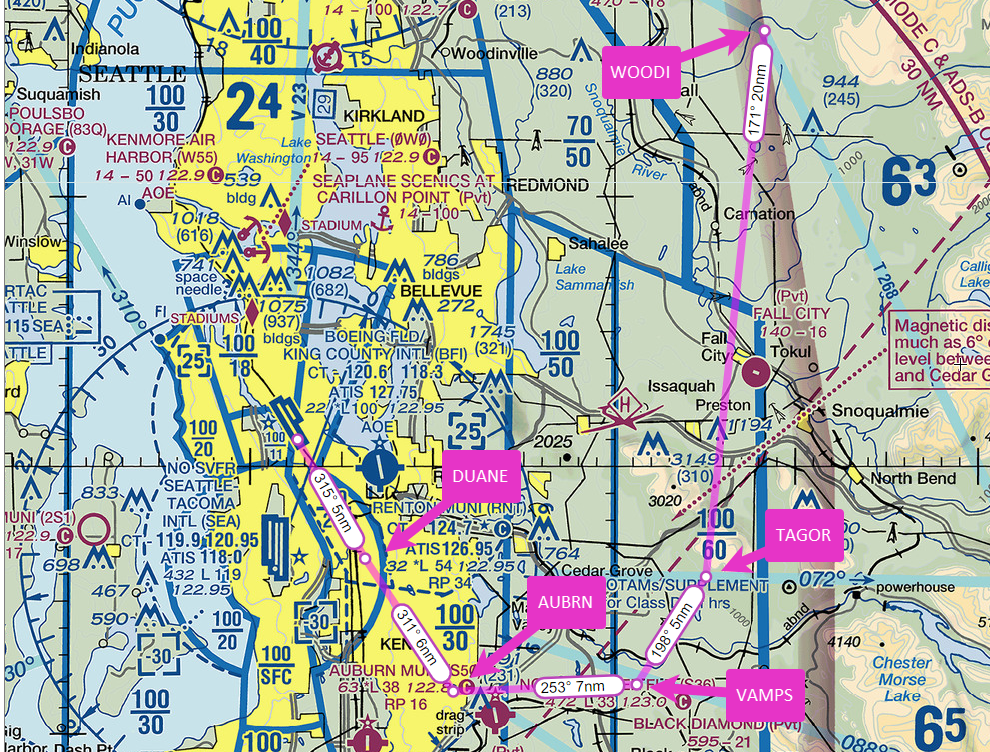
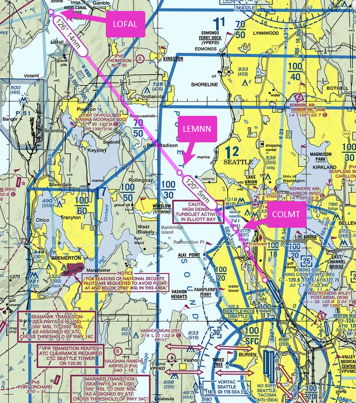
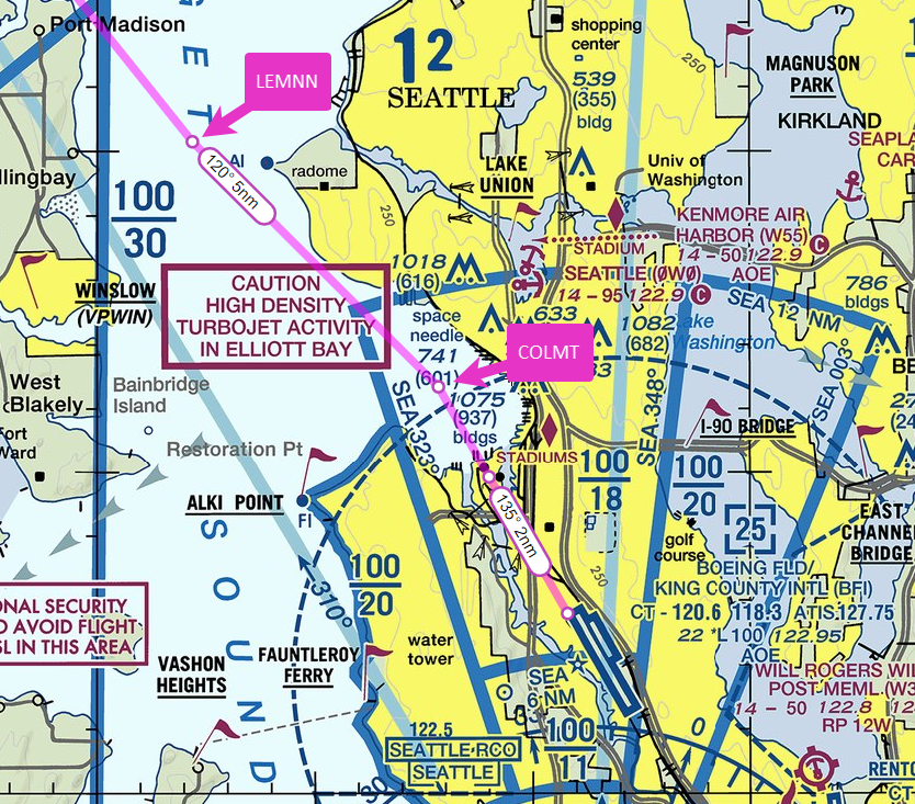
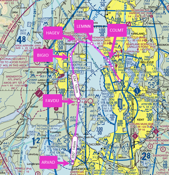
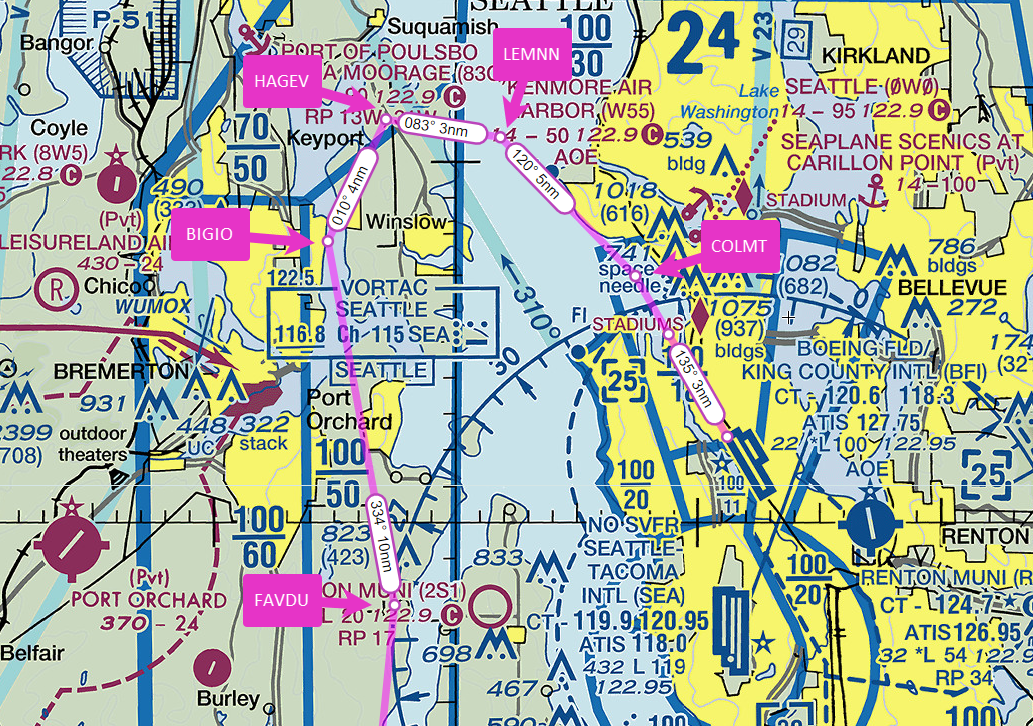
Here are detailed views of the new RNAV (GPS) RWY 14R approach, which features tracks through Elliott Bay, keeping low-altitude traffic (and noise) away from the Magnolia neighborhood. I transferred information from the approach chart to VFR charts (at SkyVector). The positions of the fixes and the tracks are approximate, but they help you visualize the new flight paths. (For similar views of the new RNAV (GPS) RWY 32L approach, scroll down.)

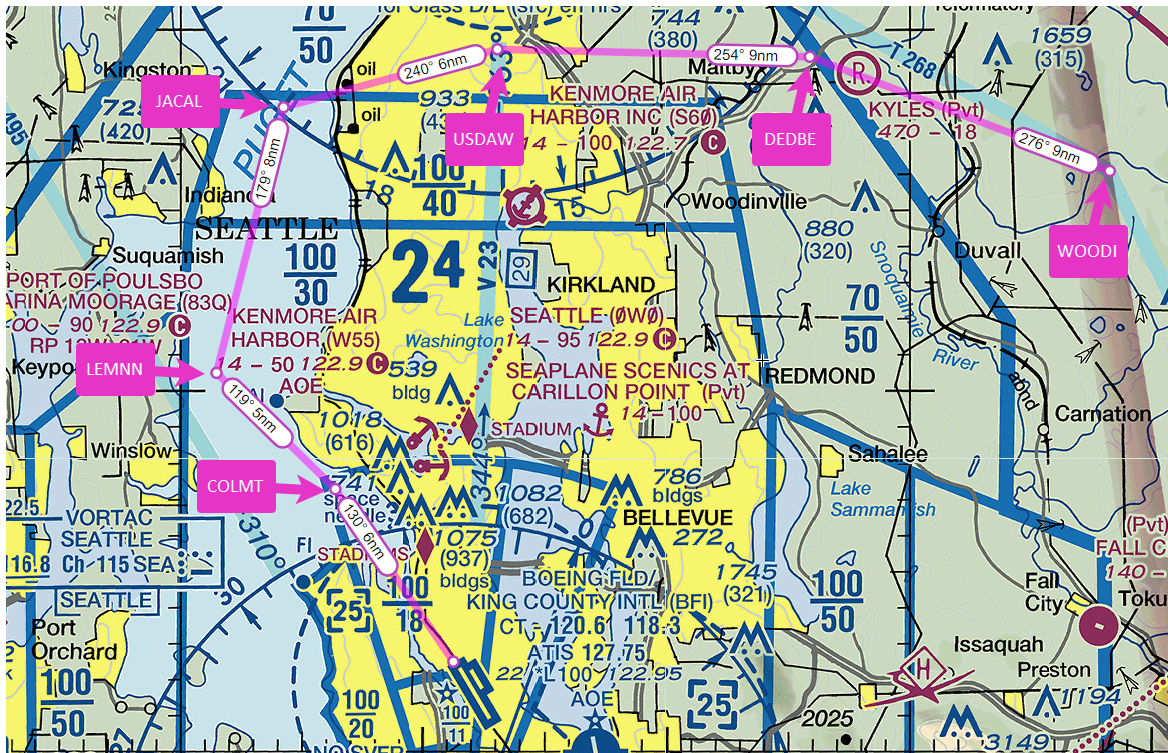
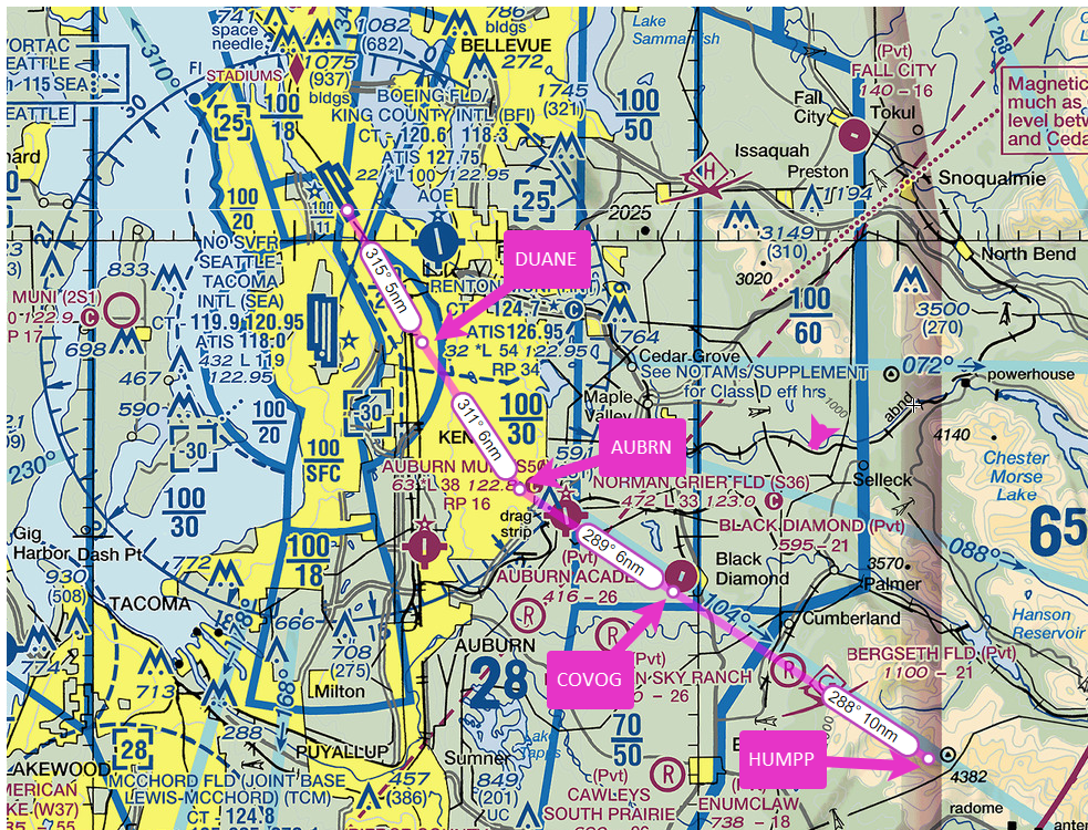
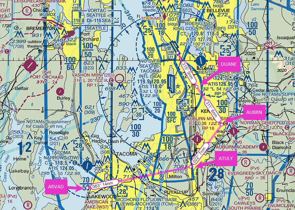
Here are views of the fixes in the new RNAV (GPS) RWY 32L approach.

A Scenic Approach to Boeing Field

I recently flew the A36 Bonanza from Boeing Field (KBFI) in Seattle to Grant County Airport (KMWH) at Moses Lake, WA and back, taking advantage of a break in the weather to cross the Cascade Mountains again before winter weather makes such trips increasingly rare.

The return to KBFI included a visual approach that passed over Seattle-Tacoma International Airport (KSEA) to a swooping descent over Puget Sound and through Elliott Bay to runway 14R.

I also captured videos of the flight to and from KMWH, which you can watch on my YouTube channel here and here.

Flying the Blake Arrival at Boeing Field

Ride along as I return to Boeing Field (KBFI) after a quick stop for fuel at the Shelton-Sanderson airport (KSHN), southwest of Seattle.

I set up for the Blake Arrival, a VFR procedure that begins over Blake Island, which lies about 8 miles west of Boeing Field.

The VFR departure and arrival routes for Boeing Field are described on the reverse side of the Seattle terminal area chart, the so-called VFR Flyway Planning Chart.

I have created more detailed descriptions of each departure and arrival route, available as a PDF in my Aviation Documents folder at OneDrive.

The Blake Island Arrival is a “south arrival” for traffic inbound from the west. It’s used when Runways 14L and 14R are active. It begins over Blake Island at 2000-2500 ft to remain below the Class B shelf in the area. You then fly direct toward Lincoln Park, just north of the Fauntleroy Ferry dock, descending to cross the shoreline at 1500 ft, then continuing down to 1000 ft, taking care to remain below and clear of the overlying Class B airspace.

Boeing Tower usually directs you to fly a right base leg for runway 14R, but sometimes, to sequence you with other traffic, ATC needs to put you on a right downwind.

Or, as happened on this day, changes your runway assignment to 14L.

Lincoln Departure at KBFI

Air traffic control has revised the Lincoln Departure at Boeing Field (KBFI) in Seattle. It’s one of the VFR procedures used at to provide an orderly flow of traffic below the Seattle Class B airspace and to avoid TCAS alerts in airliners descending over KBFI into KSEA.

As noted below, the initial altitude on the Lincoln Departure (which may be renamed the Vashon South Depature) is now 700 ft. MSL.

The Lincoln Departure almost always begins from runway 14R. It now requires a climb straight ahead to 700 ft. MSL, then a level 180-degree turn into a close-in right downwind over the Duwamish River, remaining at 800 ft. As you approach the South Park Bridge, almost abeam the control tower, turn left toward a school bus parking lot and parallel the main streets that head west over the ridge. As you reach the ridge, climb no higher than 1000 ft. Continue on a track between the north tip of Vashon Island and Blake Island. When you cross the SEA 323 degree radial, you can climb to 1500 ft. At the shoreline, you can continue to 2500 ft.