Using VNAV During an Instrument Approach

One of the terrific features available in the latest digital autopilots is VNAV, or vertical navigation. If you have a Garmin GTN-series navigator and a GFC 500 or GFC 600 autopilot, you can use VNAV to descend to the charted altitudes along the intermediate legs of an instrument approach, until you reach the final approach fix.

VNAV is also available on most G1000 systems equipped with the GFC 700 autopilot, including the new G1000 NXi, and some other manufacturers, such as Avidyne, plan to add the feature to their systems.

To see another example of using VNAV, visit VNAV with a GFC 600 Autopilot.

The 10-minute video below demonstrates how VNAV can help you fly a smooth, precise descent prior to the FAF. The video explains the basic concepts, uses the Garmin PC Trainer Suite to highlight key details, and then shows VNAV at work as I fly the RNAV (GPS) RWY 12 approach at Kelso, WA (KKLS).

For more information about VNAV, see Garmin GTN VNAV here at BruceAir. Garmin has also posted a detailed explanation of VNAV in the following video.

Garmin PC Trainer Suite Update

Garmin has updated the free the PC Trainer Suite for GTN, G500/G600 TXi, GDU 620, GNX 375, GNC 355/355A, and GPS 175. You can find the new download here.

Note that the date on the web page is January 4, 2020; it should be 2021.

The PC Trainer Suite is a great tool for learning about, teaching, and practicing with Garmin’s latest panel-mount avionics for light GA aircraft. The key display elements and logic for navigating, flying procedures, etc. is essentially the same across the Garmin line, so this trainer can also help you teach about and learn the G1000, G5, and various panel-mount GPS navigators.

The web page shows the updates and system requirements for this version, which includes navigation/procedure/chart databases from May 2020.

Video: Garmin GFC 600 Go-Around Test

My 1989 A36 Bonanza recently emerged from the shop at Pacific Coast Avionics with updates to several components. The most significant improvement, albeit one that doesn’t show off as obviously as the Garmin G500 TXi and GTN 750Xi, is the GFC 600 autopilot.

GFC 600 controller
(GMC605)

The GFC 600 replaced the original KFC 150, a state-of-the art autopilot for light aircraft in the 1980s and 1990s. It was showing its age, however, and it lacks features available in the latest generation of digital autopilots, such as the Garmin GFC 500 and GFC 600 and the Genesys S-Tec 3100.

I will have more to say about the new avionics in subsequent posts, magazine articles, and videos, but for now, here’s a video that shows a test of the coupled go-around feature of the GFC 600. I flew the ILS Y RWY 16R approach at Paine Field (KPAE) in visual conditions for this familiarization flight. At the decision altitude, I pressed the Go-Around button, and the autopilot started the climb. My job was to add power and retract the landing gear and flaps.

New GTN Guides

Pilot Workshops has published updated versions of its Pilot-Friendly manuals for the Garmin GTN 750 and GTN 650 touch-screen navigators. More details and samples here.

Full disclosure: I was the primary author of the new GTN editions, with a lot of help from the editors and graphics staff at Pilot Workshops. I also contribute to the company’s IFR and VFR training scenarios.

The books are available both in spiral-bound print editions and as PDFs.cover-gtn750

New Garmin GTN 750 Features

Garmin has released system software 6.50 (since updated to 6.51, which is a mandatory update) for its GTN 750 and GTN 650 navigators. The new software adds several features, including:

  • Vertical navigation (VNAV) capability when flying STARS and the initial stages of instrument approaches
  • Along-track offsets in flight plan segments
  • Destination airport remains in the flight plan when an approach is loaded (but the destination airport is removed when the approach is activated)
  • A shortcut to the airport info page added to all procedure headers
  • Load the approach NAV frequency from the approach header in the flight plan
  • QWERTY keyboard option

The following sections highlight some of these features. For more details on how to use the functions, see the latest editions of the GTN guides, available in my Aviation Documents folder at OneDrive and from Garmin’s product pages.

The details about this update to the GTN series are in ASDN Service Bulletin 1860, the 6.51 mandatory udpate, and the GTN 725/750 SOFTWARE v6.50 PILOT’S GUIDE UPGRADE SUPPLEMENT.

Garmin also released system software updates for the G500/600 PFD/MFD and associated hardware. For details on those updates, see ASDN Service Bulletin 1861.

Garmin has also updated its free Windows-based trainer for the GTN series.

Note that these system updates must be performed by an authorized Garmin dealer or avionics shop unless you are flying a experimental-homebuilt aircraft.

VNAV Capability

The new software adds several vertical navigation features, best illustrated with examples.

Garmin has published a video that describes the VNAV feature in detail, here.

Suppose you are flying the RNAV RWY 08 approach at Lewiston, ID (KLWS), joining the procedure at the BIDDY initial approach fix northwest of the airport. The NoPT feeder route from BIDDY specifies an an altitude of at or above 5000 ft to EVOYU, followed by a descent to at or above 4000 ft to MABIZ, and then at or above 3400 ft to the FAF at GIYES.

KLWS-RNAV-RWY08

With the new GTN system software, those segment altitudes appear in the flight plan page for the procedure.

GTN750-KLWS-RNAV08-FltPlan-01
The VNAV feature appears as a magenta vertical guidance cue next to the altitude tape on a PFD such as the new Garmin G500Txi (shown here) or the G500. Note that at this point in the approach, the LPV glidepath is a dim white diamond behind the magenta VNAV cue because the FAF is not the active waypoint and LPV is not yet annunciated on the HSI.

The VNAV cue provides advisory guidance to help you smoothly descend to each charted altitude as you fly the initial stages of the approach.

GTN750-KLWS-RNAV08-TXi-01
The LPV glidepath marker that displays approved vertical guidance replaces the VNAV cue when the FAF is active and the GTN system confirms that LPV minimums are available, as shown below.

GTN750-KLWS-RNAV08-TXi-02

Similar VNAV information and cues are available when flying a STAR, such as the MADEE FOUR arrival at Bellingham, WA (KBLI).

KBL-MADEE-4

Note that the altitudes shown in the GTN flight plan list for this STAR are for turbojet aircraft. But you can easily edit the altitude if ATC assigns a more appropriate altitude when you’re flying a typical piston-powered light aircraft.

GTN750-KBLI-MADDEE-4-01

GTN750-KBLI-MADDEE-4-02

If you are flying an approach based on an ILS, LOC, or VOR, you can quickly retrieve the navaid frequency by touching the approach title, as shown below for the ILS RWY 16 at KBLI.

GTN750-KBLI-ILS-RWY16-01.jpg

Along-Track Offsets

Suppose you are flying northeast along V2 at 13,000 ft. between ELN and MWH when Seattle Center clears you to cross 20 nm west of MWH at 9000 ft.

IFR-Low-ELN-MWH.jpg

With the new software, you can easily enter an along-track offset and display advisory vertical guidance to help you meet the restriction.

Touch MWH in the flight plan, and then touch the new Along Track button.

GTN750-AlongTrack-ELN-MWH-01

To create a waypoint for VNAV guidance, fill in the information that corresponds to your new clearance.

GTN750-AlongTrack-ELN-MWH-02
GTN750-AlongTrack-ELN-MWH-03
GTN750-AlongTrack-ELN-MWH-04
GTN750-AlongTrack-ELN-MWH-05

Airport Information

An earlier version of the GTN system software included behavior that frustrated many pilots. When you loaded an approach into a flight plan, the destination airport was removed. If you hadn’t noted details such as the tower frequency, extracting that information from the GTN’s database was cumbersome.

In version 6.50, Garmin has added an APT Info button next to the approach title in the flight plan list.

GTN750-Procedure-AirportInfoButton-01

Touching that button shows the familiar information window that provides touch access to details about the airport, including frequencies, weather, and other data.

GTN750-Procedure-AirportInfoButton-02
QWERTY Keyboard

You can also choose a QWERTY keyboard instead of the alphabetical layout in previous versions of the GTN software. The option is available on the System Setup page.

GTN750-Qwerty-01
GTN750-Qwerty-02

FAA Changing Notes on Instrument Charts

The FAA is gradually changing notes on instrument procedure charts (SIDs, STARs, and approaches) to consolidate and clarify equipment required and PBN-related information.

AOPA has published a detailed summary with background on the changes here.

The AOPA summary also includes tables that can help pilots who use Garmin equipment understand the capabilities of the avionics installed in their aircraft.


Downloading Avionics Manuals

Many pilots like to have PDF copies of the handbooks for the avionics installed in their aircraft or for reference when considering upgrades. As a flight instructor, I fly a variety of aircraft, so I keep PDFs of the pilot’s guides and cockpit references for many GPS navigators, autopilots, and other avionics on my iPad for quick reference when working with customers—and in the cockpit, as noted in AC 91-78. (The Documents feature in ForeFlight is handy way to keep these items organized and available.)

To save you the trouble of tracking down references, I keep PDF versions of the handbooks for many popular avionics in my Aviation Documents folder at OneDrive, ready for you to download. But to ensure that you always get the latest (or, if necessary, earlier versions of the manuals), visit the manufacturers’ websites.

Most avionics manufactures provide free PDF versions of their handbooks on their websites. But sometimes navigating those websites to find the references can be daunting. Here’s a quick guide to finding the handbooks for the popular Garmin GTN 750 Touchscreen GPS/Nav/Comm/MFD. You can follow a similar process to locate the handbooks for other Garmin products or the references for products sold by other avionics manufacturers.

You can find handbooks for other popular avionics at the following manufacturers’ websites. If the name of the manufacturer you’re interested in doesn’t appear in the following list, Google is your friend:

Garmin GTN 750 Handbooks

Start at the main Garmin website, www.garmin.com. In the search box in the upper-right corner, type gtn 750 (or the name of any other Garmin product).

SNAGHTML32c3eebd

In the list of the search results, click the name of the product you’re interested in.

SNAGHTML32df06d6

On the product page, click Manuals.

image

When the Manuals page appears, click Appliance Data in the Choose product version drop-down box. (Why Garmin chose Appliance Data as the name for this option is any engineer’s guess.)

image

A list of all of the handbooks and references for the GTN 750 appears. Choose the document you want to download, and copy the PDF to your device. Repeat the download step as often as necessary to collect all the documents you want. Note the revision dates and revision letters to ensure that you copy the documents that correspond to the system software installed in the units installed in your airplane.

image

Garmin Radius to Fix Leg Project Report

The accuracy provided by GPS (especially with WAAS augmentation) has vastly expanded the number and quality of instrument approaches available to properly equipped aircraft, including procedures that provide guidance comparable to the ILS. For example, as of January 10, 2013, in the U.S., there were 3,052 approaches with LPV (localizer performance with vertical guidance) minimums, more than double the number of category 1 ILS approaches (the current inventory of instrument flight procedures in the U.S. is available here).

At present, however, approaches that take full advantage of the capabilities of satellite-based navigation remain in a special “authorization required” category. Flying these RNAV (RNP) procedures requires additional crew training and approved avionics, such as flight management computers, autopilots, and cockpit displays, as described in AC 90-101A and AIM 5-4-18. At present, RNAV (RNP) (required navigation performance) procedures, like Category II ILS approaches, are available to authorized airline crews and pilots flying business jets equipped with the appropriate avionics, but not to typical instrument-rated pilots, even those flying aircraft with WAAS-capable IFR GPS navigators such as the Garmin GNS430W/530W and newer GTN750/650 series boxes.

Garmin released system software 6.11 for the GTN series on March 1, 2016. That update includes the ability to fly RF legs on approaches that are not classified as Authorization Required procedures.

The presence of RF legs no longer automatically classifies an approach as an AR procedure. For more information, see AC 90-105A and the updated Pilot’s Guide and other documentation related to the March 1, 2016 update of the system software for the Garmin GTN series navigators.

Garmin, working with the FAA and Hughes Aerospace Corporation, has recently completed the first part of a study that may persuade the FAA to change the requirements and make some RNP procedures available to most pilots flying aircraft equipped with WAAS-capable avionics. You can download the complete Garmin Radius to Fix Leg Project Report (PDF) published January 15, 2013, here.

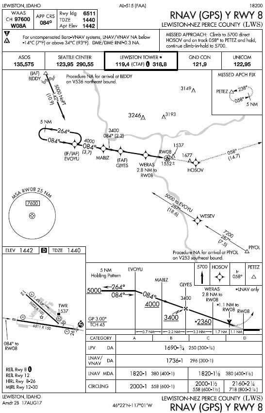
A key feature of RNP procedures is the radius-to-fix (RF) leg, a curved flight path that resembles the familiar DME arc. The Instrument Procedures Handbook describes RF legs this way:

Constant radius turns around a fix are called “radius-to-fix legs,” or RF legs. These turns, which are encoded into the navigation database, allow the aircraft to avoid critical areas of terrain or conflicting airspace while preserving positional accuracy by maintaining precise, positive course guidance along the curved track. The introduction of RF legs into the design of terminal RNAV procedures results in improved use of airspace and allows procedures to be developed to and from runways that are otherwise limited to traditional linear flight paths or, in some cases, not served by an IFR procedure at all. (5-23)

Figure A-13 from Appendix A of the IPH shows a hypothetical RF leg.

image

Unlike DME arcs, RF legs are defined by points in space, not distances from a ground-based transmitter. They can be strung together into sinuous paths, that, as noted above, provide lower minimums while avoiding obstacles, airspace conflicts, and noise-sensitive areas. The plan view from the RNAV (RNP) Z RWY 13R approach at Boeing Field in Seattle (KBFI) shows such RF legs.

image

You can find examples of RF legs in non-RNP approaches at Carlsbad, CA (KCRQ) and Ketchikan, AK (PAKT) [thanks to John D. Collins for those references]. Because of the restrictions placed on flying RF legs, however, those procedures are not currently available to typical IFR pilots. RF legs are also features of some RNAV instrument departure and arrival procedures (SIDs and STARs).

FAA includes RF legs in procedures assuming that an aircraft can follow the curved path with great precision, hence the detailed requirements spelled out in AC 90-101A, AC 90-105A, and AIM 5-4-18. Chief among those requirements are a flight director and/or a roll-steering autopilot, stipulations that rule out many, if not most, light general aviation aircraft.

The new Garmin study demonstrates, however, that:

Instrument-rated general aviation pilots are able to hand fly RF legs and meet the 0.5 nm 95% FTE [standard flight technical error]  target and RF leg altitude restrictions without the aid of a flight director or autopilot in Part 23 Category A and B aircraft that are either minimally equipped or technically advanced…All pilots demonstrated acceptable proficiency on both straight legs and RF legs. The increase in RF leg FTE over straight leg FTE can be expected to be about the same magnitude from a minimally equipped aircraft to a technically advanced aircraft.

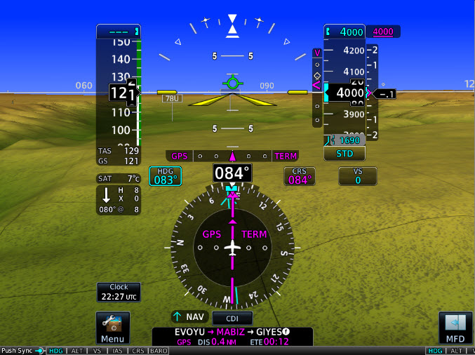
In other words, pilots were able to remain well within the boundaries specified for an RF leg, whether flying a Cherokee equipped with just a Garmin 430W and basic instrumentation or a speedier Cessna 400 outfitted with Garmin’s latest G2000 integrated glass cockpit and autopilot. The pilots achieved this performance while hand-flying challenging procedures that incorporated multiple RF legs specifically designed to stress-test both the avionics and their flying skills. You can see diagrams of these special procedures in the Garmin report.

Based on the findings (described in great detail in the Garmin document), Garmin concludes that:

Garmin recommends FAA revise its installation and operational guidance for RF legs to make clear that applicants may obtain airworthiness approval for installations without flight director/autopilot. To preclude the need to demonstrate adequate FTE margin for aircraft flying RF legs at greater than 200 knots without flight director/autopilot, Garmin recommends FAA revise its installation and operational guidance for RF legs to allow applicants to utilize an Aircraft Flight Manual limitation that restricts flying RF legs to 200 knots or less.

Furthermore, the study showed that a moving map, while a great benefit to situational awareness, isn’t necessary to fly RF legs accurately:

As this project has shown, FTE is decreased when a moving map is available and is thus consistent with the MLS curved path study conclusion that led to the FAA installation and operational guidance that “an aircraft must have an electronic map display depicting … RF legs.” However, this project has also clearly shown that a moving map is not required to maintain acceptable RF leg FTE, even during complex procedures and missed approaches.

The executive summary of the Garmin report outlines additional conclusions and recommendations that address specific issues related to flying RF legs in typical light GA aircraft.

The FAA isn’t saying when or if it will adopt the recommendations in Garmin’s report. So far, the agency has said only:

This demonstration project has shown early success and will continue with more flight testing and data collection.

But the well-designed study and detailed analysis suggest that many more pilots may in future be able to take advantage of some advanced RNP procedures, if the FAA agrees with the recommendations and avionics manufacturers and database providers include RF legs in future updates to the WAAS units now common in light GA aircraft.

Garmin released system software 6.11 for the GTN series on March 1, 2016. That update includes the ability to fly RF legs on approaches that are not classified as Authorization Required procedures. For more information, see also AC 90-105A.