The May 2023 issue of AOPA Pilot magazine includes PBN Bingo, an article I wrote to help pilots understand the key acronyms, abbreviations, and other terms associated with performance based navigation.
If you fly an airplane with a suitable RNAV system (for most of us, that’s an IFR-approved GPS navigator in the panel), you’re accustomed to flying RNAV (GPS) approaches and other procedures, such as RNAV departures and arrivals. And since most RNAV navigators currently in use also support flying ILS and VOR procedures, you also probably still fly the occasional ILS or VOR approach, even if you prefer all-GPS procedures.
But as the shift to Performance-Based Navigation (PBN) continues, the FAA is publishing more approaches that include–and sometimes require–using both GPS-based RNAV systems and ground-based navaids.
Consider the ILS or LOC RWY 12 at Huron (KHON), a small town in South Dakota.
In many respects, this is a typical ILS. It offers a DA at 200 AGL and requires 1/2 sm visibility (the RNAV (GPS) approach to RWY 12 offers the same LPV minimums). It also has an old-school locator outer marker (LOM) at BEADY that serves as the final approach fix for the LOC-only version of the approach and as the anchor for the missed-approach holding pattern.
But read the note in the required equipment box.
In most light aircraft these days, you must also have an IFR-approved GPS to fly the feeder routes and to identify BEADY, because your panel probably doesn’t include DME or an ADF.
ATC could provide vectors to steer you from the enroute environment to the final approach course. But as I’ve noted elsewhere, if you filed IFR as an RNAV/PBN-capable aircraft, a controller can clear you direct to any initial approach or intermediate fix, even if you’re flying a conventional procedure like an ILS.
The enroute chart for the area around Huron shows why you might expect such a clearance. The closest VOR at Watertown (ATY) is nearly 40 nm away, and the airways that converge at KHON are all GPS-based T-routes. The VOR at HON has been decommissioned; only the DME component remains (for more information, see Stand-Alone DMEs on Charts).
A controller can avoid issuing a series of vectors and altitudes as you fly toward the airport and offer one simple instruction, “Cross HUMSO [or WEDEM] at or above 3000, cleared for the ILS RWY 12 approach.”
Your task is to brief the plan for changing from GPS guidance to fly the feeder route from either HUMSO or WEDEM to “green needles” to intercept and track the localizer as you turn inbound toward the airport. And decide, if necessary, how you’ll fly the missed approach.
So today, even if you’re flying to a GA airport far from the big city, you should be prepared to load and fly such hybrid procedures if, for training or practice, you want to fly an ILS, LOC, or VOR approach.
The discussion of RNP–Required Navigation Performance– in AIM 1−2−2. Required Navigation Performance (RNP) and other FAA guidance confuses many pilots because the usual definition of RNP focuses on the type of equipment typically installed in bizets and airliners, not light GA aircraft.
Here are the key sentences in that AIM description of RNP:
RNP is RNAV with the added requirement for onboard performance monitoring and alerting (OBPMA). RNP is also a statement of navigation performance necessary for operation within a defined airspace. A critical component of RNP is the ability of the aircraft navigation system to monitor its achieved navigation performance, and to identify for the pilot whether the operational requirement is, or is not, being met during an operation.
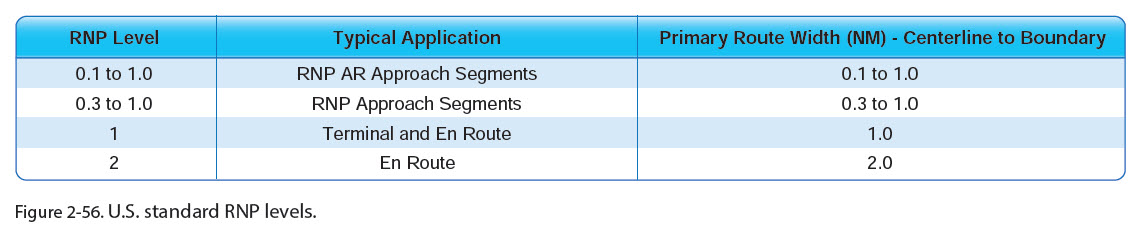
TBL 1-2-1 in the AIM shows the values, in nautical miles, associated with each standard RNP level.
Most GA pilots are concerned with only the RNP APCH (0.3 to 1.0), Terminal (1.0), and En Route (2.0) RNP levels.
Unlike the FMS and other equipment in jets, the displays in the suitable RNAV systems (i.e., GPS and WAAS navigators) and PFDs installed in our aircraft usually don’t show numerical values for RNP levels. So how you verify that your system is achieving the required navigation performance during different phases of flight?
The avionics common the light GA world typically annunciate RNP status by displaying ENR, TERM, LNAV, LPV, LP, etc., as described in the tables below from the Garmin Pilot’s Guide for the GTN series (190-02327-03D).
These letter-based RNP annunciations typically appear on the PFD near or within the HSI and on the screen for the navigator, as shown in the examples below.
A table below from the Pilot’s Guide for the Garmin G500 Txi (190-01717-10 Rev. J). provides similar information.
The LNAV, LNAV+V, LPV, LP, LP+V, and (rarely LNAV/VNAV or L/VNAV) annunciations are associated with the RNP APCH level, which is 0.3 nm for basic lateral navigation and is also used for the tighter, angular courses defined for the localizer-like final approach segments established for approaches with LPV and LP minimums.
FAA is preparing a new advisory circular, AC 90-119, which should consolidate and clarify guidance about performance-based navigation (PBN), RNAV, RNP, and related topics in one document. I submitted comments asking that tables like those above be included in the sections that define RNP values and explain how typical GA pilots can meet the requirement to monitor RNP while operating under IFR.
Many pilots are confused by the terms RNAV, RNP, and RNP APCH that appear on instrument approach charts, and it’s easy to see why.
Although ICAO is adopting a new naming standard as the world shifts to Performance Based Navigation, or PBN, the FAA is sticking to its conventions. And that approach leads to some terms having more than one meaning or to blurring important distinctions.
This video below takes a closer look at what those abbreviations, initialisms, and notes mean.
The revised draft of AC 90-119 was released for public comment on September 27, 2023. You can download the PDF from the FAA website here. Comments on the draft are due October 26, 2023.
You can read my detailed initial comments on the first draft here (PDF).
This advisory circular (AC) replaces and consolidates several ACs…and provides guidance for operators using Performance-based Navigation (PBN) in the United States, in oceanic and remote continental airspace, and in foreign countries that adopt International Civil Aviation Organization (ICAO) PBN standards.
The draft AC includes updates to FAA policy in some key areas, and it will replace several existing guidance documents, including:
AC 90-100A CHG 2, U.S. Terminal and En Route Area Navigation (RNAV) Operations, dated April 14, 2015;
AC 90-105A, Approval Guidance for RNP Operations and Barometric Vertical Navigation in the U.S. National Airspace System and in Oceanic and Remote Continental Airspace, dated March 7, 2016;
AC 90-107, Guidance for Localizer Performance with Vertical Guidance and Localizer Performance without Vertical Guidance Approach Operations in the U.S. National Airspace System, dated February 11, 2011; and
AC 90-108 CHG 1, Use of Suitable Area Navigation (RNAV) Systems on Conventional Routes and Procedures, dated April 21, 2015.
The language in this AC also affects sections of the AIM; FAA handbooks such as the Instrument Flying Handbook and Instrument Procedures Handbook; and Airmen Certification Standards that include instrument tasks.
Key Updates
Here are some of the key updates to FAA guidance and policy in the new AC. Detailed discussion of each item follows.
Use of suitable RNAV systems on conventional routes and procedures, which clarifies how you can use an IFR-approved GPS on all types of IFR procedures, including those that use localizer courses, until you reach the final approach segment.
Expanded definition and clarification of the term RNP APCH, which many pilots confuse with RNP AR APCH. FAA adds RNP APCH notes to approaches with RNAV (GPS) in the title and does not plan to adopt current ICAO conventions for naming PBN procedures (for background, see this post here at BruceAir). More details on this topic appear below.
Updated definition of precision approach, which now explicitly includes all RNAV (GPS) approaches with LPV minimums. The AC also aligns FAA terminology with the ICAO definitions for procedures that include 2D (lateral navigation) and 3D (lateral and vertical navigation).
Use of Suitable RNAV Systems on Conventional Routes and Procedures
For general aviation pilots who use IFR-approved GPS and WAAS avionics, the draft AC clarifies a key issue, the use of RNAV (i.e., GPS and WAAS) while flying routes and procedures based on navaids. In particular, Chapter 11 describes specific situations in which pilots can use RNAV as an alternate means of navigation or as a substitute for navaids, and the document clarifies when you can use GPS to navigate along localizer courses outside the final approach segment.
(I recently gave a webinar for the American Bonanza Society on this topic. You can watch that presentation here and read more about the topic here.)
The draft AC provides the following updated definitions:
11.1.1.1 Alternate Means of Navigation. The pilot’s use of a suitable RNAV system to navigate on a conventional route or procedure without monitoring the operational NAVAID(s) defining the route or procedure. “Alternate means” applies to a situation where the pilot has options or a choice, and uses the suitable RNAV system primarily for convenience.
11.1.1.2 Substitute Means of Navigation. The pilot’s use of a suitable RNAV system to navigate on a conventional route or procedure in an aircraft with inoperative or not-installed conventional navigation equipment and/or when conventional NAVAIDs are out of service. “Substitution” applies to a situation where the NAVAID or the aircraft equipment are inoperative or unavailable (i.e., the pilot cannot use or monitor the conventional NAVAID).
11.1.1.3 Suitable RNAV System. Per § 1.1, an RNAV system is suitable when it (1) is installed for IFR operations, and (2) meets the navigation performance criteria required by ATC for the route or procedure to be flown. Put simply, suitable RNAV systems are those that meet the criteria identified in this AC for RNAV operations.
Section 11.4.2 Authorized Uses of Suitable RNAV Systems describes specific situations in which you can use GPS to complement or substitute for ground-based navaids.
The most significant update is item 6 (reinforced by paragraph 11.4.3.3), which clarifies that you can use GPS to navigate all legs of any conventional approach procedure, including procedures based on a localizer, until you reach final approach segment:
1. Determine aircraft position relative to, or distance from, a conventional NAVAID, DME fix, or named fix based on a conventional NAVAID.
2. Navigate to or from any conventional NAVAID or fix, via direct or a defined course.
3. Hold over any conventional NAVAID or DME fix.
4. Fly a published arc based upon DME.
5. Fly a route, comprised of charted airways, fixes, and/or NAVAIDs.
6. Navigate to the FAS of a conventional IAP.
7. Navigate the lateral course of the FAS on an IAP based on a VOR, Tactical Air Navigation System (TACAN), or Non-Directional Beacon (NDB) signal. The aircraft equipment and underlying NAVAID must be operational and monitored for FAS course alignment. The underlying NAVAID remains the primary source of navigation for the FAS course and should be used for course alignment if the RNAV system track differs from the underlying NAVAID course.
Items 1-2 also mean that you can use RNAV to fly departures and arrivals based on conventional navaids.
Item 6 is backed up by additional paragraphs:
11.4.3.1 On Unusable or Not Authorized (NA) Procedures. Pilots may not fly any portion of a conventional route or procedure identified (by chart annotation or NOTAM) as unusable or not authorized (“NA”).
Note: Pilots should take particular care when loading routes by name or title, especially routes defined solely by conventional NAVAIDs. Conventional routes designated as “unusable” by chart notation or NOTAM are unusable by any user. Pilots should not file for, and ATC should not use, the unusable route title or name in the IFR clearance. This does not preclude the use of direct clearances to usable waypoints along or across a charted route designated as “unusable.” [For more background on this issue, see Unusable Airways, Routes, and Segments here at BruceAir.]
11.4.3.2 As Sole Means of Navigation on Conventional FAS. Pilots may not use RNAV as the sole means of navigation to fly the final approach course on a conventional instrument approach.
11.4.3.3 To Navigate a Localizer (LOC) Final Approach Course. Pilots may not use RNAV to fly a FAS defined by an LOC signal.
Together, these sections mean that you can use an IFR-approved GPS to fly departures; airways; arrivals; feeder routes; track a VOR radial or localizer course to a course reversal or HILPT; fly DME arcs; fly holds, including holds based on DME fixes; and to fly the legs of missed approach procedures based on navaids, including localizers.
Paragraph 11.4.3.2As Sole Means of Navigation on Conventional FAS emphasizes that you cannot use GPS for lateral guidance along the final approach segment of a VOR or NDB approach unless the navaid is operational and you can monitor the course on a bearing pointer or CDI. This paragraph aligns with previous guidance in the AIM and AFM supplements, as I’ve noted in several posts here at BruceAir.
RNP APCH
Paragraph 12.3 RNP APCH Overview provides background on the use of the note RNP APCH, which now appears on many charts.
This note is one way that FAA attempts to align its naming conventions for PBN approaches with updated ICAO standards (for background, see FAA InFO16020). As the AC explains:
In the United States, RNP APCH applies to all approach applications based on Global Positioning System (GPS), normally titled “RNAV (GPS)” or with “or GPS” in the title. These procedures provide operators one or more lines of minima (i.e., LNAV, LNAV/VNAV, LPV, or LP)…The RNP APCH NavSpec is intended to encompass all segments of the terminal approach operation: initial, intermediate, final, and missed approach…Charts for RNP APCH procedures will prominently display a standardized PBN Notes Box containing the procedure’s requirements including NavSpec(s) and, if needed, any required sensors or additional functionality (e.g., RF capability), as well as any minimum RNP value required for the procedure, and applicable remarks.
In other words, in the U.S., GPS-based approaches are titled RNAV (GPS) RWY xx. These approaches also include a RNP APCH note to confirm that they require the equipment needed to fly to the RNP terminal and final approach standards (i.e., RNP 1 and RNP 0.3 for LNAV minimums to an MDA or LPV, LNAV/VNAV to a DA, or LP standards for lateral guidance to an MDA).
RNP APCH is not the same as the authorization required to comply with the RNP AR APCH standard. In the U.S. approaches that require the RNP AR APCH standard are titled RNAV (RNP) RWY xx.
As the draft AC notes:
This AC does not apply to Required Navigation Performance Authorization Required Approach (RNP AR APCH) approaches, titled “RNAV (RNP)” (ICAO: RNP RWY xx (AR)). Guidance for RNP AR operations is in AC 90-101( ), Approval Guidance for RNP Procedures with AR.
Definition of Precision Approach
The draft AC updates the definition of precision approach, which now explicitly includes all RNAV (GPS) approaches with LPV minimums. The AC also aligns FAA terminology with the ICAO definitions for procedures that include 2D (lateral navigation) and 3D (lateral and vertical navigation).
In the past, precision approach applied only to procedures based on ground facilities that provide a glideslope or other approved vertical guidance to a DA–viz., an ILS or PAR. That obsolete definition required the creation of a new term, APV (approaches with vertical guidance), for RNAV procedures that offer approved vertical guidance to LPV or LNAV/VNAV decision altitude minimums.
Today, ICAO has updated its definition of precision approach by describing procedures that include approved vertical guidance to a DA, so-called 3D navigation. ICAO also describes so-called 2D approaches to MDAs.
With that change in mind, the new AC explains precision approaches (PA) and nonprecision approaches (NPA) that use GPS:
12.3.1.1 NPA Operations. These two-dimensional (2D) operations use GPS-derived lateral guidance from the RNP system. The procedure provides obstruction clearance as long as the pilots strictly adhere to the published minimum altitudes along the approach course, primarily by reference to the barometric altimeter. These 2D procedures typically have LNAV lines of minima to a minimum descent altitude (MDA).
12.3.1.2 PA Operations. These 3D operations use either ground-based, GPS-derived, and/or integrated electronic vertical guidance from the RNP system to enable lateral and vertical navigation to decision altitude (DA)/decision heights (DH) at or below 250 feet above ground level (AGL) (depending on the presence of obstacles). Typically, these are shown as LPV or LNAV/VNAV (and ILS/GLS) DA/DHs.
This section of the AC also notes that:
Note 2: Some approach procedures that contain both precision and nonprecision features are internationally designated as “Approaches with Vertical Guidance (APV).” These 3D approach procedures use GPS or SBAS to generate integrated electronic vertical and lateral guidance from the RNP system. These procedures typically have LNAV/VNAV lines of minima to DA/DH as low as 251 feet AGL. In the United States, all procedures to a LPV DA (regardless of height above touchdown (HAT)) are considered 3D precision operations. [Emphasis added]
This change should help reduce confusion about when IFR students and applicants for instrument ratings can use RNAV (GPS) approaches with LPV minimums to accomplish requirements for practicing and demonstrating precision approaches on practical tests.
The AC includes updated guidance in several other areas, beyond technical requirements for approval and use of RNAV systems.
For example, paragraph 3.6.7.4 Extract Procedures by Name notes that:
Pilots should extract PBN procedures by name from the onboard navigation database and ensure the extracted procedures match the charted procedures.
Note 1: Pilots operating aircraft with some early-model legacy RNAV navigators may not be able to extract certain PBN departure and arrival procedures by name from the navigation database. In these aircraft, pilots may load the departure or arrival procedures by extracting the individual fixes defining the procedures from the navigation database and loading them into the flight plan for their aircraft’s RNAV system. When this is necessary, pilots should confirm the resulting flight plan content matches the charted PBN procedure.
Note 2: Pilots are also cautioned that some procedures, even if extracted by name from the database, may not contain every segment, turn point, or conditional waypoint, or may contain “computer navigation fixes (CNF)” not shown on the procedure. It is always the pilot’s responsibility to ensure the aircraft’s flightpath conforms to the ATC clearance.
Paragraph 3.6.7.5 Extract PBN Routes in Their Entirety cautions that:
Pilots should extract the PBN routes from the navigation database whenever possible rather than loading the route by stringing individual fixes defining the route in sequence.
Note 1: This does not preclude a pilot’s use of a legacy RNAV navigator that cannot auto-load a PBN route into the navigator’s flight plan. A pilot may load a PBN route by extracting the individual fixes defining the route from the onboard navigation database and loading into the flight plan, fix by fix. When this is necessary, pilots should confirm the resulting flight plan route entries match the charted routes.
Note 2: Caution is warranted when loading routes into the RNAV system for convenience, especially conventional routes defined by ground NAVAIDs. Routes designated as “unusable” by chart notation or NOTAM are unusable by any user. Pilots should not file for, and ATC should not use, the unusable route title or name in the IFR clearance. This does not preclude the use of “direct to” clearances to usable waypoints along a charted route designated as “unusable.”
Paragraph 3.6.7.6 Creating or Altering Waypoints also warns that:
For any published (i.e., charted) PBN routes or procedures, pilots may only use waypoints downloaded from the aircraft navigation database. Pilots may not create waypoints (e.g., by using latitude/longitude coordinates, place/bearing, or any other means) for use on published PBN routes or procedures. Pilots also may not change any parameters of waypoints downloaded from the navigation database (e.g., changing a flyover waypoint to a flyby waypoint).
Paragraph 3.6.7.7 Cross-Check Flight Plan Against ATC Clearance recommends that:
Pilots should cross-check the navigation system’s flight plan against their ATC clearance and the charted routes and procedures. Both the flight plan’s textual display and the aircraft’s electronic moving map display (when available) can aid in this cross-check. When required by NOTAM or by the aircraft’s operating manual and SOP, pilots should confirm exclusion of specific ground-based navigation aids. If at any time during these cross-checks, a pilot doubts the validity of the route or procedure they extracted from the navigation database, they should not attempt to execute the route or procedure.
Note: Pilots may notice a slight difference between the navigation information portrayed on the chart and their primary navigation display. Differences of up to 5 degrees may result from avionics’ application of magnetic variation. These differences are acceptable.
Paragraph 3.6.10 and others in that section explain equipment required notes on PBN procedures. I won’t repeat all those details here. You can find background at Equipment Required Notes on IFR Procedure Charts here at BruceAir. I’ll update that post when I can distill the current FAA guidance as described in the new AC.
Finally, section 3.7 Training offers detailed guidance on the steps pilots should take to ensure that they understand how to use RNAV systems. A list appears in paragraph 3.7.3. Many of these items are also covered in existing industry guidance, such as the free Garmin GTN 750 Sample Training Syllabus (PDF).
5−2−9. Instrument Departure Procedures (DP) − Obstacle Departure Procedures (ODP), Standard Instrument Departures (SID), and Diverse Vector Areas (DVA)
5−4−1. Standard Terminal Arrival (STAR) Procedures
5−4−5. Instrument Approach Procedure (IAP) Charts
There was not enough adequate information concerning Performance−Based Navigation (PBN) and Advanced Required Navigational Performance (A−RNP) available to flight crews and operators in the AIM. This expansion in the description and advantages of these navigation specifications (NavSpecs) will provide better guidance as to what A−RNP is, how it will be applied, and its applicability in the PBN NAS. Additional information is being added to better clarify NavSpecs, RNP, and PBN understanding in AIM Chapter 1. Associated paragraph changes are necessary to ensure harmonization between all the paragraphs in the AIM.
5−1−8. Flight Plan (FAA Form 7233−1) − Domestic IFR Flights
This change updates pilot guidance to incorporate air traffic control (ATC) procedures for GNSS−equipped aircraft operating on area navigation (RNAV) air traffic service (ATS) routes and on random point−to−point and random impromptu routes in airspace in which ATC procedures are applied, excluding oceanic airspace. This change also incorporates the use of the term GNSS in place of RNAV for space−based positioning and navigation systems.
Area Navigation, RNAV, RNP, and A-RNP
AIM 1−2−1 includes new explanations of RNAV and performance-based navigation (PBN). Before reviewing the new information in this section of the AIM, it’s important to remember that AIM 1−1−17. Global Positioning System (GPS) notes that:
(5) Aircraft navigating by IFR−approved GPS are considered to be performance−based navigation (PBN) aircraft and have special equipment suffixes.
The specific capabilities of the GNSS (GPS) in your panel are described in the AFM Supplement and operating handbooks for the equipment (as updated when new system software is installed). You can find more information about RNAV and RNP specs in AC 90-105 and at RNP Procedures and Typical Part 91 Pilots here at BruceAir.
With that in mind, it’s important to understand that if your airplane is equipped with, say, a Garmin GNS530W/GNS530W or GTN 750/650 (with an appropriate AFM supplement), you can fly RNAV SIDs and STARs based on RNP-1 criteria. And you can also fly en route segments that require RNP-2 accuracy. No special authorization is required at these RNP levels.
For more information about RNP levels, see “Required Navigation Performance” in the Instrument Procedures Handbook (2-34).
Figure 9-41 in the Instrument Flying Handbook is also helpful.
Update to AIM 1−2−1. General
Here’s the new language in AIM 1-2-1, the introduction to PBN. Note that RAIM, used to validate the accuracy and reliablity of non-WAAS GPS for use under IFR, qualifies as “onboard performance monitoring and alerting capability” for purposes of PBN and basic RNP. WAAS, which incorporates its own performance and accuracy checking system, also provides onboard performance monitoring and alerting capability.
a. Introduction to PBN. As air travel has evolved, methods of navigation have improved to give operators more flexibility. PBN exists under the umbrella of area navigation (RNAV). The term RNAV in this context, as in procedure titles, just means “area navigation,” regardless of the equipment capability of the aircraft…Many operators have upgraded their systems to obtain the benefits of PBN. Within PBN there are two main categories of navigation methods or specifications: area navigation (RNAV) and required navigation performance (RNP). In this context, the term RNAV x means a specific navigation specification with a specified lateral accuracy value. For an aircraft to meet the requirements of PBN, a specified RNAV or RNP accuracy must be met 95 percent of the flight time. RNP is a PBN system that includes onboard performance monitoring and alerting capability (for example, Receiver Autonomous Integrity Monitoring (RAIM)). PBN also introduces the concept of navigation specifications (NavSpecs) which are a set of aircraft and aircrew requirements needed to support a navigation application within a defined airspace concept. For both RNP and RNAV NavSpecs, the numerical designation refers to the lateral navigation accuracy in nautical miles which is expected to be achieved at least 95 percent of the flight time by the population of aircraft operating within the airspace, route, or procedure. This information is detailed in International Civil Aviation Organization’s (ICAO) Doc 9613, Performance−based Navigation (PBN) Manual and the latest FAA AC 90−105, Approval Guidance for RNP Operations and Barometric Vertical Navigation in the U.S. National Airspace System and in Remote and Oceanic Airspace.
Required Navigation Performance (RNP)
Here’s the new language in AIM 1−2−2.
a. General. While both RNAV navigation specifications (NavSpecs) and RNP NavSpecs contain specific performance requirements, RNP is RNAV with the added requirement for onboard performance monitoring and alerting (OBPMA). RNP is also a statement of navigation performance necessary for operation within a defined airspace. A critical component of RNP is the ability of the aircraft navigation system to monitor its achieved navigation performance, and to identify for the pilot whether the operational requirement is, or is not, being met during an operation. OBPMA capability therefore allows a lessened reliance on air traffic control intervention and/or procedural separation to achieve the overall safety of the operation. RNP capability of the aircraft is a major component in determining the separation criteria to ensure that the overall containment of the operation is met. The RNP capability of an aircraft will vary depending upon the aircraft equipment and the navigation infrastructure. For example, an aircraft may be eligible for RNP 1, but may not be capable of RNP 1 operations due to limited NAVAID coverage or avionics failure. The Aircraft Flight Manual (AFM) or avionics documents for your aircraft should specifically state the aircraft’s RNP eligibilities. Contact the manufacturer of the avionics or the aircraft if this information is missing or incomplete. NavSpecs should be considered different from one another, not “better” or “worse” based on the described lateral navigation accuracy. It is this concept that requires each NavSpec eligbility to be listed separately in the avionics documents or AFM. For example, RNP 1 is different from RNAV 1, and an RNP 1 eligibility does NOT mean automatic RNP 2 or RNAV 1 eligibility. As a safeguard, the FAA requires that aircraft navigation databases hold only those procedures that the aircraft maintains eligibility for. If you look for a specific instrument procedure in your aircraft’s navigation database and cannot find it, it’s likely that procedure contains PBN elements your aircraft is ineligible for or cannot compute and fly. Further, optional capabilities such as Radius−to−fix (RF) turns or scalability should be described in the AFM or avionics documents. Use the capabilities of your avionics suite to verify the appropriate waypoint and track data after loading the procedure from your database.
RNP Approach (RNP APCH) and RNP AR APCH
The new language in this section of the AIM intends to address confusion about RNP and approaches. Unfortunately, because FAA continues to use RNAV in procedure titles, many pilots remain puzzled about the differences between the terms RNAV, RNP APCH, and RNP AR APCH. As this part of the revised AIM 1−2−2 notes:
In the U.S., RNP APCH procedures are titled RNAV (GPS) and offer several lines of minima to accommodate varying levels of aircraft equipage: either lateral navigation (LNAV), LNAV/vertical navigation (LNAV/VNAV), Localizer Performance with Vertical Guidance (LPV), and Localizer Performance (LP).
(1) RNP Approach (RNP APCH). In the U.S., RNP APCH procedures are titled RNAV (GPS) and offer several lines of minima to accommodate varying levels of aircraft equipage: either lateral navigation (LNAV), LNAV/vertical navigation (LNAV/VNAV), Localizer Performance with Vertical Guidance (LPV), and Localizer Performance (LP). GPS with or without Space−Based Augmentation System (SBAS) (for example, WAAS) can provide the lateral information to support LNAV minima. LNAV/VNAV incorporates LNAV lateral with vertical path guidance for systems and operators capable of either barometric or SBAS vertical. Pilots are required to use SBAS to fly to the LPV or LP minima. RF turn capability is optional in RNP APCH eligibility. This means that your aircraft may be eligible for RNP APCH operations, but you may not fly an RF turn unless RF turns are also specifically listed as a feature of your avionics suite. GBAS Landing System (GLS) procedures are also constructed using RNP APCH NavSpecs and provide precision approach capability. RNP APCH has a lateral accuracy value of 1 in the terminal and missed approach segments and essentially scales to RNP 0.3 (or 40 meters with SBAS) in the final approach. (See Paragraph 5−4−18, RNP AR Instrument Approach Procedures.)
(2) RNP Authorization Required Approach (RNP AR APCH). In the U.S., RNP AR APCH procedures are titled RNAV (RNP). These approaches have stringent equipage and pilot training standards and require special FAA authorization to fly. Scalability and RF turn capabilities are mandatory in RNP AR APCH eligibility. RNP AR APCH vertical navigation performance is based upon barometric VNAV or SBAS. RNP AR is intended to provide specific benefits at specific locations. It is not intended for every operator or aircraft. RNP AR capability requires specific aircraft performance, design, operational processes, training, and specific procedure design criteria to achieve the required target level of safety. RNP AR APCH has lateral accuracy values that can range below 1 in the terminal and missed approach segments and essentially scale to RNP 0.3 or lower in the final approach. Before conducting these procedures, operators should refer to the latest AC 90−101, Approval Guidance for RNP Procedures with AR. (See paragraph 5−4−18.)
Advanced RNP (A−RNP)
If you’re keeping up so far, the new language in AIM 1−2−2 provides more details about Advanced RNP (A-RNP), not to be confused with RNP (AR). Some features of A-RNP, such as the ability to fly some RF legs, are available if you have the current system software installed in a Garmin GTN navigator. For more information, see Garmin GTN Avionics and RF Legs here at BruceAir.
(4) Advanced RNP (A−RNP). Advanced RNP is a NavSpec with a minimum set of mandatory functions enabled in the aircraft’s avionics suite. In the U.S., these minimum functions include capability to calculate and perform RF turns, scalable RNP, and parallel offset flight path generation. Higher continuity (such as dual systems) may be required for certain oceanic and remote continental airspace. Other “advanced” options for use in the en route environment (such as fixed radius transitions and Time of Arrival Control) are optional in the U.S. Typically, an aircraft eligible for A−RNP will also be eligible for operations comprising: RNP APCH, RNP/RNAV 1, RNP/RNAV 2, RNP 4, and RNP/RNAV 10. A−RNP allows for scalable RNP lateral navigation values (either 1.0 or 0.3) in the terminal environment. Use of these reduced lateral accuracies will normally require use of the aircraft’s autopilot and/or flight director. See the latest AC 90−105 for more information on A−RNP, including NavSpec bundling options, eligibility determinations, and operations approvals.
NOTE−
A−RNP eligible aircraft are NOT automatically eligible for RNP AR APCH or RNP AR DP operations, as RNP AR eligibility requires a separate determination process and special FAA authorization.
(5) RNP 1. RNP 1 requires a lateral accuracy value of 1 for arrival and departure in the terminal area, and the initial and intermediate approach phase when used on conventional procedures with PBN segments (for example, an ILS with a PBN feeder, IAF, or missed approach). RF turn capability is optional in RNP 1 eligibility. This means that your aircraft may be eligible for RNP 1 operations, but you may not fly an RF turn unless RF turns are also specifically listed as a feature of your avionics suite.
(6) RNP 2. RNP 2 will apply to both domestic and oceanic/remote operations with a lateral accuracy value of 2.
PBN Requirement Boxes
AIM 1−2−2 now includes language about equipment requirement boxes on procedures that include PBN elements. For more information, see New Equipment Required Notes and An ILS that Requires GPS here at BruceAir.
(c) Depiction of PBN Requirements. In the U.S., PBN requirements like Lateral Accuracy Values or NavSpecs applicable to a procedure will be depicted on affected charts and procedures. In the U.S., a specific procedure’s Performance−Based Navigation (PBN) requirements will be prominently displayed in separate, standardized notes boxes. For procedures with PBN elements, the “PBN box” will contain the procedure’s NavSpec(s); and, if required: specific sensors or infrastructure needed for the navigation solution, any additional or advanced functional requirements, the minimum RNP value, and any amplifying remarks. Items listed in this PBN box are REQUIRED to fly the procedure’s PBN elements. For example, an ILS with an RNAV missed approach would require a specific capability to fly the missed approach portion of the procedure. That required capability will be listed in the PBN box. The separate Equipment Requirements box will list ground−based equipment and/or airport specific requirements. On procedures with both PBN elements and ground−based equipment requirements, the PBN requirements box will be listed first.
Flying and Flying Direct with GNSS (GPS)
AIM 5−1−8 now provides more details for pilots flying under IFR with GNSS about filing direct routes or requesting direct clearances from ATC. The new text focuses on direct routes that include legs that exceed navaid service volumes and provides more details about filing direct routes.
In particular, if you plan a direct flight you should:
File and fly point-to-point using published waypoint names (airports, navaids, intersections, and RNAV waypoints) to define the route of flight.
Include at least one named waypoint within each ARTCC through which the flight will pass.
4. Increasing use of self−contained airborne navigational systems which do not rely on the VOR/VORTAC/TACAN system has resulted in pilot requests for direct routes that exceed NAVAID service volume limits. With the exception of GNSS−equipped aircraft, these direct route requests will be approved only in a radar environment, with approval based on pilot responsibility for navigation on the authorized direct route. Radar flight following will be provided by ATC for ATC purposes. For GNSS−equipped aircraft, ATC may approve a direct route that exceeds ground based NAVAID service volume limits; however, in a non−radar environment, the routing must be “point−to−point,” defined as navigation from a published point to a published point, and navigational assistance will not be available. (See subparagraph 5−1−8d below.)
5. At times, ATC will initiate a direct route in a radar environment that exceeds NAVAID service volume limits. In such cases ATC will provide radar monitoring and navigational assistance as necessary. For GNSS−equipped aircraft, if the route is point−to−point, radar monitoring and navigational assistance is not required. (See subparagraph 5−1−8d below.)
d. Area Navigation (RNAV)/Global Navigation Satellite System (GNSS) 1. Except for GNSS−equipped aircraft, random impromptu routes can only be approved in a radar environment. A random impromptu route is a direct course initiated by ATC or requested by the pilot during flight. Aircraft are cleared from their present position to a NAVAID, waypoint, fix, or airport. Factors that will be considered by ATC in approving random impromptu routes include the capability to provide radar monitoring and compatibility with traffic volume and flow. ATC will radar monitor each flight; however, navigation on the random impromptu route is the responsibility of the pilot. GNSS−equipped aircraft are allowed to operate in a non−radar environment when the aircraft is cleared via, or is reported to be established on, a point−to−point route. The points must be published NAVAIDs, waypoints, fixes, or airports recallable from the aircraft’s database. The distance between the points cannot exceed 500 miles and navigational assistance will not be provided…
(f) File a minimum of one route description waypoint for each ARTCC through whose area the random route will be flown.
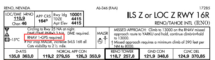
You can still fly IFR in the U.S. without an IFR-approved GNSS (i.e., GPS), but being “slant G” (/G in the soon-to-be obsolete FAA domestic flight plan format) increasingly offers advantages, even if you fly only conventional procedures based on ground navaids. And sometimes an IFR-approved GNSS is required to fly even an ILS.
But the equipment required notes for this ILS approach include “RNAV-1 GPS required.”
A review of the plan view and missed approach track show why GPS is necessary to fly this procedure.
First, you need GPS to fly transitions from most of initial fixes, which are RNAV waypoints marked by a star symbol.
Only LIBGE, directly north of the runway, is a non-RNAV IAF.
For example, HOBOA, KLOCK, BELBE, and WINRZ are all RNAV waypoints that serve as IAFs or IFs. Now, NORCAL Approach might provide vectors to the final approach course, but if you want to fly this procedure you should be prepared for a clearance direct to one of those fixes (see Avoiding the Vectors-to-Final Scramble).
Note also that entire missed approach track requires use of GNSS.
Two of the transitions are of special note. The “arcs” that begin at ZONBI and SLABS are radius-to-fix (RF) legs that are part of the transitions that begin at HOBOA and KLOCK. Each of those fixes is distinguished by the notes “RNP-1 GPS REQD” and “RF REQD.”
The first note means that your GPS must meet the RNP 1 standard, which is used for terminal procedures such as SIDs and STARs, the initial phases of approaches, and missed-approach segments. (For more information about RNP, see RNP Procedures and Typical Part 91 Pilots.)
Until recently, RF legs were included only in Authorization Required (AR) procedures. But as I explained in Garmin GTN Avionics and RF Legs, certain RF legs are now available if you have an appropriate GNSS navigator, updated system software, an electronic HSI, and other equipment. Some limitations on flying such RFs also apply, as described in that earlier post.
Suppose that you choose the less intimidating ILS X or LOC X RWY 16R to the same runway. A review of the notes and the plan view shows that even this conventional-looking ILS also requires RNAV 1 GPS, both to fly the transition from WINRZ and the missed approach track.
To learn more about the capabilities of Garmin panel-mount avionics, including the various G1000 and GTN-series products, see Garmin Performance-Based Navigation Capabilities (PDF), a brochure published by Garmin.
Until recently, RF legs were published only on so-called RNP procedures with authorization required (AR) restrictions (for more information, see AIM 5−4−18: RNP AR Instrument Approach Procedures). But FAA has started publishing some approaches with RF legs (like the example above) that are not designated as RNP AR procedures. And, with some limitations, pilots who fly aircraft equipped with GTN-series avionics should be able to fly the RF legs used as transitions/feeder routes on those approaches. (Note that so far, these approaches don’t require RF capability–conventional transitions/feeder routes and/or radar vectors are also available.)
The revised STC for the GTN series (document 190-01007-A5) notes that:
GPS/SBAS TSO-C146c Class 3 Operation …The Garmin GNSS navigation system complies with the equipment requirements of AC 90-105 and meets the equipment performance and functional requirements to conduct RNP terminal departure and arrival procedures and RNP approach procedures including procedures with RF legs subject to the limitations herein [emphasis added].
Sections 2.12 RF Legs and 2.13.1 RNP 1.0 RF Leg Types of the STC add the following information:
2.12 RF Legs This STC does not grant operational approval for RF leg navigation for those operators requiring operational approval. Additional FAA approval may be required for those aircraft intending to use the GTN as a means to provide RNP 1 navigation in accordance with FAA Advisory Circular AC 90-105. [Note that per AC 90-105A, domestic Part 91 operations do not require additional approval–only Part 91 subpart K operations and commercial operations need LOAs or the equivalent FAA approval.]
The following limitations apply to procedures with RF legs:
Aircraft is limited to 180 KIAS while on the RF leg
RF legs are limited to RNP 1 procedures. RNP AR and RNP <1 are not approved
Primary navigation guidance on RF legs must be shown on an EHSI indicator with auto-slew capability turned ON
GTN Moving Map, EHSI Map, or Distance to Next Waypoint information must be displayed to the pilot during the RF leg when flying without the aid of the autopilot or flight director.
The active waypoint must be displayed in the pilot’s primary field of view…
2.13.1 RNP 1.0 RF Leg Types AC 90-105 states that procedures with RF legs must be flown using either a flight director or coupled to the autopilot.
This STC has demonstrated acceptable crew workload and Flight Technical Error for hand flown procedures with RF legs when the GTN installation complies with limitation set forth in Section 2.12 of this document. It is recommended to couple the autopilot for RF procedures, if available, but it is not required to do so. See section 4.5 of this manual to determine if this capability is supported in this installation.
At present, only a few non-AR approaches with RF legs meet the criteria in the STC and AC 90-105A. But RF legs could become more common on “standard” procedures to provide paths that offer better noise abatement, reduce airspace conflicts, and improve ATC efficiency, and pilots flying with GTN avionics (or similar navigators offered by other manufacturers) will be able to fly those procedures.
As of August 27, 2019, FAA requires that all flight plans (VFR, IFR, domestic, and international) use the ICAO format.
Most pilots file flight plans electronically, typically via an app or website such as ForeFlight, Garmin Pilot, or Fltplan.com, so many of the details of the ICAO plan form (electronic or on paper) aren’t important. Fill in the basic information such as departure, route, destination, and ETD, and the apps and websites ensure that data are formatted correctly.
The most difficult hurdle for pilots new to the ICAO format is figuring out the correct codes and other details about the aircraft that you fly. But once you enter the information about the aircraft into the app(s) that you use, filing ICAO is trivial.
In November 2013, FAA updated and simplified some of the requirements for filing ICAO flight plans for domestic use. You can read about those changes here (PDF). Note that the instructions from FAA focus on the printed flight plan form, which few pilots use. Apps such as ForeFlight, Garmin Pilot, WingX, FltPlanGo, go FlyQ take care of many of the details for you. You should review the user guides and other instructions for the apps and web-based tools that you use to file flight plans. ForeFlight has detailed information about ICAO flight plans here.
Confusing Codes
Many pilots are confused by elements of the ICAO flight plan format, especially the multiple aircraft equipment codes that you must include to inform ATC of the gizmos and capability that are installed in your aircraft.
The following guide should help you sort out those ICAO codes if you fly a typical light GA aircraft equipped with at least one WAAS-capable, GPS navigator that is approved to fly RNAV (GPS) approaches. Examples of such avionics include:
Here’s a look at the relevant parts of the ICAO flight plan form as shown on the Leidos FSS website. You can find a video that describes the ICAO flight plan form at Leidos FSS here.
I’ve filled in the information for my Beechcraft A36 Bonanza (ICAO identifier BE36), which is equipped with a GTN750, a Garmin GTX 327 transponder (not Mode S), and the GDL 88 ADS-B transmitter and receiver. This aircraft also has a Bendix/King DME receiver.
For more information about the ICAO identifiers to use for the makes and models of aircraft that you fly, see ICAO Aircraft Type Designators here at BruceAir.
The example is for an IFR trip from KBFI to KGEG in the Pacific Northwest. The route includes the ZOOMR1 STAR into KGEG.
Basic Information
The first few items are the same for all typical IFR general aviation flights:
Flight Rule: IFR
Flight Type: G (for general aviation)
Number of Aircraft: 1 (i.e., not a formation flight)
Wake Turbulence Category: L (for light)
Aircraft Type: The official ICAO designator for the make and model of aircraft you fly (e.g., BE36, C172, C210, M20P, PA28A, etc.)
Aircraft Equipment
On the familiar FAA domestic flight plan form, equipment suffixes for typical GA pilots are simple, and if you’re flying a GPS-equipped airplane with a Mode C transponder, the basic /G was all you needed.
But the ICAO form captures many more details about the equipment installed in your aircraft, and the fun typically begins with this item.
For a WAAS-equipped aircraft such as we’re discussing, you should enter the following codes in the Aircraft Equipment box:
SBDGR
As you can see in the illustration from the Leidos FSS web form, these letters represent the following equipment:
S: Standard communication and navigation receivers/transmitters (VOR, VHF communications radios, and ILS receiver). If you enter S in this box, you shouldn’t include the letters L (ILS), O (VOR), or V (VHF) here. S includes that equipment.
B: LPV approach capability. If you have a WAAS GPS, but your installation isn’t approved for LPV procedures (see the user’s guide and AFM supplement), omit this letter.
D: DME. If you don’t have DME, omit the D.
G: IFR-approved GPS (the preferred term is now GNSS, Global Navigation Satellite System)
R: PBN approved. This letter means that your aircraft meets basic RNP standards. All aircraft with an IFR-approved GPS are PBN approved (see AIM 1-2-1). You must include R, and associated information in the Other Information box, to ensure that the computer will accept a routing that includes RNAV routes, SIDs, STARs, or charted ODPs. See PBN and RNP Confusion, below.
Z: Indicates additional information to be added to the Other Information box, described below.
If you still have an ADF, include F.
PBN and RNP Confusion
The aviation world uses RNP (required navigation performance) for two related, but different purposes.
In general, RNP is an RNAV specification (e.g., RNAV 5, RNAV 2, and RNAV 1) that indicates that an aircraft is capable of maintaining a course (track) within designated limits 95 percent of the time. For example, RNAV 5 means the aircraft as equipped can reliably maintain a track with 5 nm; RNAV 2 limits are 2 nm, and so forth. If your aircraft is equipped with an IFR-approved GPS authorized to fly RNAV (GPS) approaches, it matches this sense of RNP and PBN.
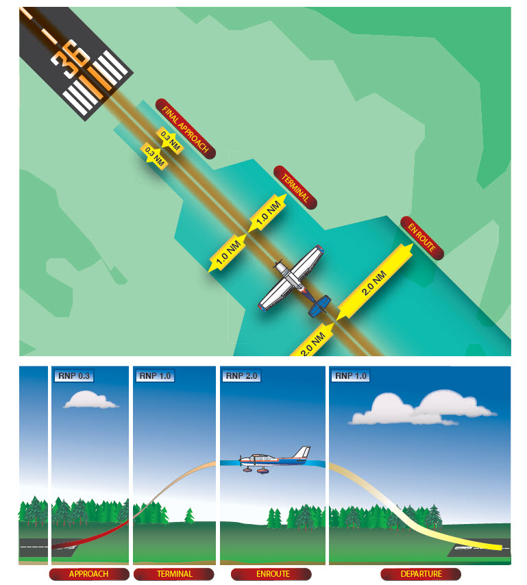
The basic RNP (RNAV) specifications used in the U.S. (RNP 0.3, RNP 1.0, RNP 2.0, and RNP 1.0) are shown in the following illustration from the Instrument Flying Handbook (FAA H-8083-15B). For more information about RNP and RNAV specifications, see “Required Navigation Performance” on page 9-44 of the IFH.
Current WAAS-approved GPS receivers for typical GA aircraft, such as those listed earlier, meet the U.S. RNP specifications, as described in AC 90-100A: U.S Terminal and En Route Area Navigation (RNAV) Operations and the associated AC 90-100 Compliance document (PDF). To confirm your GPS receiver’s capabilities, check the user guides and the AFM supplements for the equipment installed in your aircraft.
The term RNP is also applied as a descriptor for airspace, routes, and procedures (including departures, arrivals, and IAPs). RNP can apply to a unique approach procedure or to a large region of airspace. In this sense, RNP means something similar to Category II and Category III instrument approaches. For example, an approach with RNP in the title (e.g., RNAV (RNP) Z RWY 16R) requires special equipment and detailed crew training/qualification. Such RNAV (RNP) approaches include the note AUTHORIZATION REQUIRED on the chart.
This box on the ICAO form tells ATC what type of transponder and related equipment are installed in your aircraft.
For most GA pilots flying IFR, this box will include at least C, for a transponder with altitude-reporting capability.
If you have a Mode S transponder, you should select the appropriate letter, E, H, I, L, P, S, or X, based on the information in the user guide and AFM supplement for your transponder.
If you have ADS-B equipment installed (not a portable ADS-B receiver such as the Stratus or Dual XGPS170), include U1or U2. The Garmin GDL 88 in my airplane both transmits and receives ADS-B signals, so I add U2 to this box.
Other Information
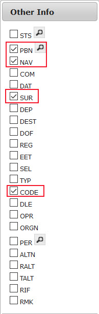
The final box for designating your RNAV capabilities and additional data is Other Information. You must use prefixes, followed by letters, to include different categories of information.
As described above here and here, it’s important to add a PBN/ group in this box to ensure that the ATC system understands the RNP/RNAV capabilities of your aircraft.
If you have a GPS approved for at least IFR en route and terminal operations, add the following letters:
C2, which designates RNAV 2 capability based on GPS (GNSS)
D2, which designates RNAV 1 capability based on GPS (GNSS)
If you have a Mode S transponder that complies with the ADS-B out requirements, add the following group to this box:
SUR/260B
If you have a UAT box such as the Garmin GDL 88 to meet the ADS-B requirements, add the following group to this box:
SUR/282B
You should also file the six-digit Mode S Code (base 16 / hex) assigned to your aircraft by inserting a CODE/ group. You can find the hexadecimal code for your aircraft by checking the FAA N-number registry:
CODE/xxxxxx
For example, the code for one of the aircraft at the flight school where I instruct is A66E8E. The entry for that aircraft is:
You can also add a NAV/ group in this box to indicate your RNAV capability. This group isn’t necessary if you use the appropriate PBN codes described above. But you can use a NAV/ group such as D1E2A1to indicate that you have RNAV 1 capability for departure, RNAV 2 capability for the en route segment, and RNAV 1 capability for arrival.
NAV/RNVD1E2A1
These groups and letters mean that you can fly RNAV routes (e.g., T-routes), RNAV SIDs and STARs, and charted ODPs (charted ODPs are often RNAV procedures, usually based on GPS).
Don’t worry about the options in the RNP Specifications part of this box. Unless you are authorized to fly RNAV (RNP) procedures (see above), these items don’t apply to you.
Summary
Here’s a quick review of what to put in the equipment-related boxes of the ICAO flight plan form if, like me, you fly an aircraft with one of the common IFR-approved, WAAS-capable GPS receivers:
Aircraft Equipment: SBGR
Surveillance Equipment: C (for a Mode C transponder). (If you have ADS-B in/out capability, such as a Garmin GDL 88, add U2. If you have a Mode S transponder, include the appropriate letter for your model.)
Other Information: PBN/C2D2 SUR/260B or SUR/282B and CODE/xxxxxx (where xxxxxx is the six-digit hexadecimal code assigned to your aircraft as part of its registration record at the FAA).
The accuracy provided by GPS (especially with WAAS augmentation) has vastly expanded the number and quality of instrument approaches available to properly equipped aircraft, including procedures that provide guidance comparable to the ILS. For example, as of January 10, 2013, in the U.S., there were 3,052 approaches with LPV (localizer performance with vertical guidance) minimums, more than double the number of category 1 ILS approaches (the current inventory of instrument flight procedures in the U.S. is available here).
At present, however, approaches that take full advantage of the capabilities of satellite-based navigation remain in a special “authorization required” category. Flying these RNAV (RNP) procedures requires additional crew training and approved avionics, such as flight management computers, autopilots, and cockpit displays, as described in AC 90-101A and AIM 5-4-18. At present, RNAV (RNP) (required navigation performance) procedures, like Category II ILS approaches, are available to authorized airline crews and pilots flying business jets equipped with the appropriate avionics, but not to typical instrument-rated pilots, even those flying aircraft with WAAS-capable IFR GPS navigators such as the Garmin GNS430W/530W and newer GTN750/650 series boxes.
Garmin released system software 6.11 for the GTN series on March 1, 2016. That update includes the ability to fly RF legs on approaches that are not classified as Authorization Required procedures.
The presence of RF legs no longer automatically classifies an approach as an AR procedure. For more information, see AC 90-105A and the updated Pilot’s Guide and other documentation related to the March 1, 2016 update of the system software for the Garmin GTN series navigators.
Garmin, working with the FAA and Hughes Aerospace Corporation, has recently completed the first part of a study that may persuade the FAA to change the requirements and make some RNP procedures available to most pilots flying aircraft equipped with WAAS-capable avionics. You can download the complete Garmin Radius to Fix Leg Project Report (PDF) published January 15, 2013, here.
A key feature of RNP procedures is the radius-to-fix (RF) leg, a curved flight path that resembles the familiar DME arc. The Instrument Procedures Handbook describes RF legs this way:
Constant radius turns around a fix are called “radius-to-fix legs,” or RF legs. These turns, which are encoded into the navigation database, allow the aircraft to avoid critical areas of terrain or conflicting airspace while preserving positional accuracy by maintaining precise, positive course guidance along the curved track. The introduction of RF legs into the design of terminal RNAV procedures results in improved use of airspace and allows procedures to be developed to and from runways that are otherwise limited to traditional linear flight paths or, in some cases, not served by an IFR procedure at all. (5-23)
Figure A-13 from Appendix A of the IPH shows a hypothetical RF leg.
Unlike DME arcs, RF legs are defined by points in space, not distances from a ground-based transmitter. They can be strung together into sinuous paths, that, as noted above, provide lower minimums while avoiding obstacles, airspace conflicts, and noise-sensitive areas. The plan view from the RNAV (RNP) Z RWY 13R approach at Boeing Field in Seattle (KBFI) shows such RF legs.
You can find examples of RF legs in non-RNP approaches at Carlsbad, CA (KCRQ) and Ketchikan, AK (PAKT) [thanks to John D. Collins for those references]. Because of the restrictions placed on flying RF legs, however, those procedures are not currently available to typical IFR pilots. RF legs are also features of some RNAV instrument departure and arrival procedures (SIDs and STARs).
FAA includes RF legs in procedures assuming that an aircraft can follow the curved path with great precision, hence the detailed requirements spelled out in AC 90-101A, AC 90-105A, and AIM 5-4-18. Chief among those requirements are a flight director and/or a roll-steering autopilot, stipulations that rule out many, if not most, light general aviation aircraft.
The new Garmin study demonstrates, however, that:
Instrument-rated general aviation pilots are able to hand fly RF legs and meet the 0.5 nm 95% FTE [standard flight technical error] target and RF leg altitude restrictions without the aid of a flight director or autopilot in Part 23 Category A and B aircraft that are either minimally equipped or technically advanced…All pilots demonstrated acceptable proficiency on both straight legs and RF legs. The increase in RF leg FTE over straight leg FTE can be expected to be about the same magnitude from a minimally equipped aircraft to a technically advanced aircraft.
In other words, pilots were able to remain well within the boundaries specified for an RF leg, whether flying a Cherokee equipped with just a Garmin 430W and basic instrumentation or a speedier Cessna 400 outfitted with Garmin’s latest G2000 integrated glass cockpit and autopilot. The pilots achieved this performance while hand-flying challenging procedures that incorporated multiple RF legs specifically designed to stress-test both the avionics and their flying skills. You can see diagrams of these special procedures in the Garmin report.
Based on the findings (described in great detail in the Garmin document), Garmin concludes that:
Garmin recommends FAA revise its installation and operational guidance for RF legs to make clear that applicants may obtain airworthiness approval for installations without flight director/autopilot. To preclude the need to demonstrate adequate FTE margin for aircraft flying RF legs at greater than 200 knots without flight director/autopilot, Garmin recommends FAA revise its installation and operational guidance for RF legs to allow applicants to utilize an Aircraft Flight Manual limitation that restricts flying RF legs to 200 knots or less.
Furthermore, the study showed that a moving map, while a great benefit to situational awareness, isn’t necessary to fly RF legs accurately:
As this project has shown, FTE is decreased when a moving map is available and is thus consistent with the MLS curved path study conclusion that led to the FAA installation and operational guidance that “an aircraft must have an electronic map display depicting … RF legs.” However, this project has also clearly shown that a moving map is not required to maintain acceptable RF leg FTE, even during complex procedures and missed approaches.
The executive summary of the Garmin report outlines additional conclusions and recommendations that address specific issues related to flying RF legs in typical light GA aircraft.
The FAA isn’t saying when or if it will adopt the recommendations in Garmin’s report. So far, the agency has said only:
This demonstration project has shown early success and will continue with more flight testing and data collection.
But the well-designed study and detailed analysis suggest that many more pilots may in future be able to take advantage of some advanced RNP procedures, if the FAA agrees with the recommendations and avionics manufacturers and database providers include RF legs in future updates to the WAAS units now common in light GA aircraft.
Garmin released system software 6.11 for the GTN series on March 1, 2016. That update includes the ability to fly RF legs on approaches that are not classified as Authorization Required procedures. For more information, see also AC 90-105A.