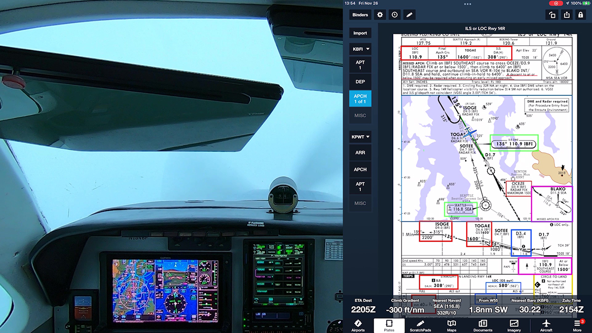
Charts for instrument procedures include a lot of information, and IFR pilots learn to brief departures, arrivals, and approaches as part of the preparation for takeoff, descent, and landing.
Often, however, those briefings aren’t especially effective, because the pilot or crew just recites data on the chart and doesn’t actually prepare to fly the procedure by describing a plan that includes details such as how:
You will join the procedure.
You will use and monitor navigation sources (GPS or ground-based navaids) to track the initial and final approach segments of the procedure and to enhance situational awareness.
You plan to configure the aircraft during an approach, especially along the final approach segment.
You will navigate the missed approach segment.
In other words, just reading a chart aloud doesn’t truly prepare you to fly a procedure. It’s like trying to sight-read a piece of music instead of practicing before a recital. And too often, a traditional briefing is also rushed or juggled with other tasks, especially in an aircraft equipped with modern avionics.
Today most IFR pilots fly with at least some electronic displays and GPS navigators, and we use electronic flight bags—tablets and apps—to plan our flights on the ground and to display charts and related information in the air. Given the way we now fly IFR, it’s time to update the briefing process to reflect modern avionics and the tools we bring into the cockpit.
For a detailed explanation of how I teach procedure briefings, see:
For procedures with PBN elements, the PBN box will contain the procedure’s navigation specification(s); and, if required: specific sensors or infrastructure needed for the navigation solution; any additional or advanced functional requirements; the minimum Required Navigation Performance (RNP) value and any amplifying remarks. Items listed in this PBN box are REQUIRED. The separate Equipment Requirements Box will list ground-based equipment requirements. On procedures with both PBN elements and ground-based equipment requirements, the PBN requirements box will be listed first.
The publication of the new notes will continue incrementally until all charts have been amended to comply with the new standard.
A sample of the new notes boxes is below.
Here’s an example of the requirements box on the recently updated chart for the ILS RWY 28R approach at Billings, MT (KBIL):
Many pilots who use sophisticated GPS-based navigators have difficulty consistently loading and flying approaches. As I’ve noted elsewhere, pilots who use the vectors-to-final option may find themselves scrambling to comply with a clearance that directs them to a specific fix in the approach. Other pilots fumble with activating an approach, a process that sometimes leads the airplane in an unexpected direction.
AIM 5−4−6. Approach Clearance
6. …RNAV aircraft may be issued a clearance direct to the IAF/IF at intercept angles not greater than 90 degrees for both conventional and RNAV instrument approaches. Controllers may issue a heading or a course direct to a fix between the IF and FAF at intercept angles not greater than 30 degrees for both conventional and RNAV instrument approaches.
Many instructors, myself included, have long advocated using the flight plan page on your navigator to simplify flying instrument approaches (and SIDs and STARs). In fact, the flight plan page or menu is typically the most misunderstood and least-utilized feature of most GPS navigators.
I’ve created a short presentation that guides you through the process of loading (and “activating”) an approach on the Garmin GTN 750. The presentation, Flying an Approach with the GTN 750, is available as a free PDF that you can download from the Aviation Documents folder at my OneDrive page. You can find many more useful, free references there.
The basic technique and principles described in the presentation apply to most IFR-approved GPS navigators, but you should, of course, review the handbook and AFM supplement applicable to the unit in the aircraft that you fly.
After reviewing the presentation, practice with the free simulators available from Garmin and fly with an instructor or safety pilot in VMC before you launch on an actual IFR flight.
The FAA continues to publish more GPS-based instrument procedures. The latest inventory shows that as of February 6, 2014, there are 13,134 RNAV (GPS) approaches available for general use in the U.S. National Airspace System. (That number doesn’t include the RNP authorization-required procedures available only to pilots and aircraft that meet the requirements of AC 90-101A. More about RNP and AR procedures here.)
By comparison, there are 5,794 ILS, LOC, NDB, and VOR approaches (again, not counting CAT II, CAT III, and other procedures that require special training, equipment, and authorizations).
RNAV (GPS) Procedures
GPS (Stand – Alone)
140
RNAV (LNAV)
5,832
RNAV (VNAV)
3,254
RNAV (LPV)
3,375
RNAV (LP)
533
Total
13,134
Conventional Approaches
ILS
1,285
LOC
1,439
LOC (B/C)
72
NDB
780
VOR
1,273
VOR/DME
945
Total
5,794
Here’s a pie chart that shows the relative shares of different types of instrument approach procedures in the U.S.
Perhaps more important to general-aviation pilots is the fact that so many of the RNAV (GPS) procedures—especially those with LPV minimums—are at smaller airports that don’t have an ILS:
3,364 LPVs serving 1,661 airports
2,262 LPVs to non-ILS runways
1,535 LPVs to non-ILS airports
1,102 LPVs to ILS runways
2,020 LPVs to non-Part 139 airports (airports not approved for airline operations)
The other day at BeechTalk, a forum for owners and operators of Beechcraft (Bonanzas, Barons, and the like) a long, surprisingly contentious, thread started with a simple question: When can I cancel IFR?
The pilot who posed the question described a common situation. An IFR aircraft is approaching an airport that does not have an operating control tower. Other airplanes are en route to the same airport or are waiting on the ground for a release to depart. When the current weather is IMC, ATC can allow only one aircraft at any time to operate under IFR (or special VFR) within the (usually) Class E airspace surrounding the airport. Until an approaching aircraft cancels IFR, either in the air or after landing, no other aircraft can fly an approach or depart under an IFR clearance.
FAA publishes telephone numbers that pilots can use to cancel IFR and obtain an IFR release at non-towered airports that don’t have an RCO or GCO. The numbers are listed in the Chart Supplement (A/FD) listings for most airports. More information about this topic is available here at BruceAir.
Bowerman Airport (KHQM) on the southwest Washington coast is an example of such an airport. It does not have a control tower, and, as indicated by the dashed magenta lines, it is enclosed by surface-based Class E airspace (as opposed to Class E airspace that begins at 700 ft. AGL). The surfaced-based Class E airspace extends west and east of the airport to protect the final approach paths for the instrument approaches that serve KHQM.
Suppose you are approaching KHQM on an IFR clearance. You fly one of published procedures and at some point during the descent, you break into the clear below the clouds. When ATC cleared you for the approach, the controller directed you to report canceling your IFR flight plan either on an ATC frequency or by calling an ATC facility on the phone. You know (or suspect) that other aircraft are waiting to follow you or to depart KHQM, so you are eager to cancel IFR as soon as possible to free up the airspace. It’s often much easier and faster to cancel IFR directly with the controller you’ve been talking to than to use a ground communication outlet or to relay a cancelation via radio or a cell phone call.
But when can you legally cancel IFR? The basic answer is in AIM 5−1−15. Canceling IFR Flight Plan.
b. An IFR flight plan may be canceled at any time the flight is operating in VFR conditions outside Class A airspace…
The key to that statement is “operating in VFR conditions.” And that stipulation depends on both the weather and the type of airspace you’re operating in.
If the ASOS at KHQM, which is surrounded by surface-based Class E airspace, is reporting a ceiling less than 1,000 ft. and/or visibility less than 3 miles, you can’t cancel IFR until you are on the ground. That’s because 14 CFR § 91.155 Basic VFR weather minimums stipulates:
(c) Except as provided in § 91.157, no person may operate an aircraft beneath the ceiling under VFR within the lateral boundaries of controlled airspace designated to the surface for an airport when the ceiling is less than 1,000 feet.
(d) Except as provided in § 91.157 of this part, no person may take off or land an aircraft, or enter the traffic pattern of an airport, under VFR, within the lateral boundaries of the surface areas of Class B, Class C, Class D, or Class E airspace designated for an airport—
(1) Unless ground visibility at that airport is at least 3 statute miles; or
(2) If ground visibility is not reported at that airport, unless flight visibility during landing or takeoff, or while operating in the traffic pattern is at least 3 statute miles.
In other words, if the official weather report for the airport indicates that the current weather is less than the minimum for basic VFR in Class E airspace, you can’t legally operate under VFR below the ceiling. In particular, the regulation specifically notes that you can’t take off or land at an airport inside surface-based Class E airspace under VFR when the ceiling is less than 1,000 ft. Flying clear of clouds and having the airport in sight is not the same as “operating in VFR conditions.”
Some pilots argue that, regardless of the weather reported by an AWOS or ASOS, they can cancel IFR or enter the Class E airspace under VFR if their flight visibility allows them to continue under VFR. But the Baginski Letter (2012) from FAA contradicts this notion:
“The pilot’s report of flight conditions cannot supersede the AWOS in this scenario. The determination of the visibility by a pilot is not an official weather report or official ground visibility report. See 14 CFR 91.157(d).”
You have more flexibility if the weather is better. If the ASOS reports a ceiling of, say, 1,300 ft. and more than 3 miles visibility (in other words, KHQM is officially, if only marginally, VFR), you could legally cancel IFR when you reach 800 ft. AGL. (500 ft. below the cloud bases). Of course, throughout the remainder of your approach and landing, you must observe the cloud clearance and visibility requirements for Class E airspace as stipulated in § 91.155:
500 feet below
1,000 feet above
2,000 feet horizontal
In marginal VFR conditions, a few wispy clouds often lurk around the airport. To meet the letter of the law, you must make sure that you can clear all of them by at least 2,000 ft. horizontally and 500 ft. vertically.
Here’s video of an approach to Bremerton, WA (KPWT). ATC gave me two frequencies available for canceling my IFR flight plan–one to use while airborne; the other to contact them after I landed. Given the weather at KPWT (400 BKN), the only legal option was canceling after landing.
It’s important to keep this discussion in perspective. When the weather is marginal and you’re flying an approach, canceling as soon as you break out (even if doing so were legal given current conditions) saves only a couple of minutes versus canceling after landing and clearing the runway. Flying another lap around a holding pattern, slowing down, accepting a delay vector, or idling at the hold-short line at the runway for a few minutes while you wait for a release is occasionally part of flying IFR.
Canceling on the ground can be more cumbersome than speaking directly to the controller who cleared you. But even if the airport doesn’t have good radio coverage on the ground and you have to call ATC on the phone, it’s usually not a big deal. We all have cell phones. Many of us can connect our phones to our headsets or audio panels via Blutetooth. You can also relay your IFR cancelation through another aircraft that is high enough to communicate directly with ATC.
FAA is publishing telephone numbers that pilots can use to cancel IFR and obtain an IFR release at non-towered airports. The numbers are listed in the Chart Supplement (A/FD) listings for most airports without control towers or RCOs or GCOs. More information about this topic is available here at BruceAir.
We all like to help ATC and our fellow pilots by clearing the airspace for the next airplane on approach or to assist the pilot waiting for a release to depart. But trying to sort out the legality of canceling in the air during a critical phase of flight just isn’t worth the risk of distraction or violating the FARs, especially when the delay is so short. If you don’t break out in obvious VMC with plenty of time to juggle canceling, monitoring the CTAF, and keeping an eye out for traffic, land the plane and cancel when you’re safely clear of the runway.