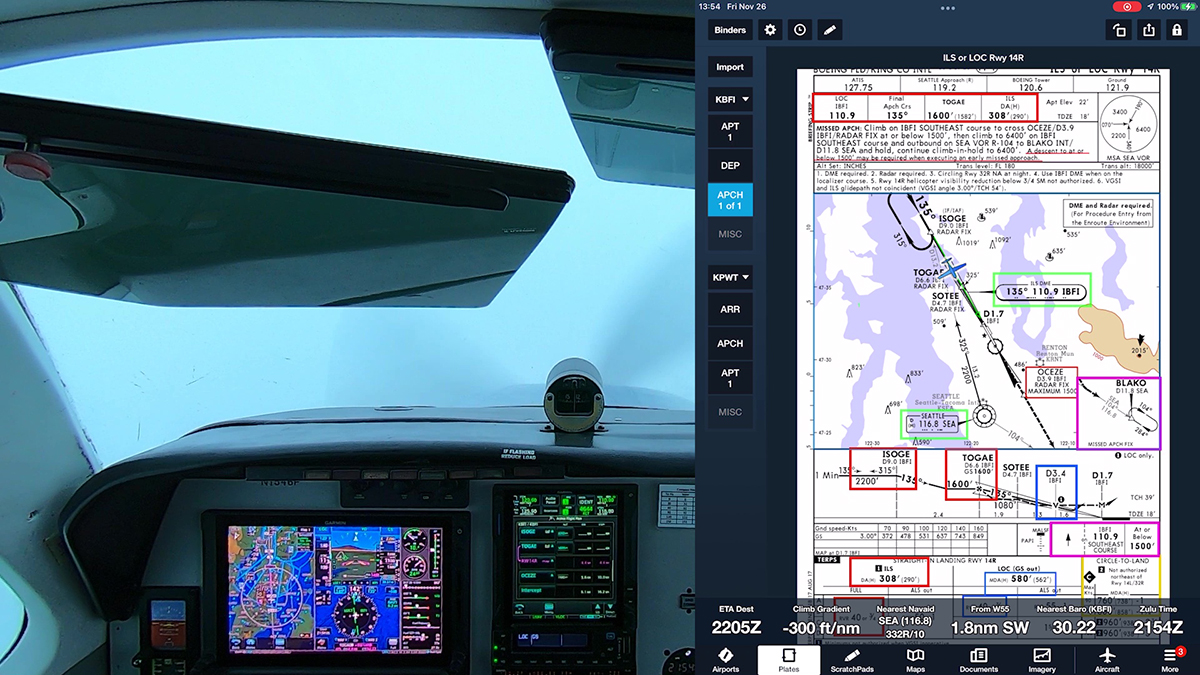
Video: Tips for IFR Flights

Fall weather finally arrived in Seattle, so I took advantage of IFR-and MVFR conditions to fly the Bonanza on a short hop from Boeing Field (KBFI) to Arlington (KAWO).

A glitch meant that I didn’t capture ATC or intercom audio on this flight, so instead this video describes some of the techniques and procedures that I use on a typical IFR flight. And I explain how I dealt with an unexpected curve during the approach at Arlington.

A flight from Boeing Field to Arlington in the Bonanza typically involves only about 20 minutes in the air. Under IFR, it’s important to manage the workload—updating the preflight briefing with the latest information, obtaining an IFR clearance, setting up the airplane and avionics, flying a departure procedure, and being ready to begin an approach as soon as you level off.

For example, before I even start the engine, I call the phone numbers for the ATIS or AWOS at my departure and destination and fill in the ForeFlight scratchpads. That way, I have the basic information and I can quickly confirm the current ATIS letter and update the one-minute weather when I contact ATC before takeoff and as I begin the approach that I want to fly, based on the wind and other details.

See the video for other tips, such as annotating charts and loading–but not activating–approaches.

Opposing Bases: Air Traffic Talk

I just found a series of podcasts hosted by a pair of working air traffic controllers who are also pilots: Opposing Bases: Air Traffic Talk

Welcome to Opposing Bases: Air Traffic Talk.  Our aviation podcast is delivered by two experienced pilots that work as air traffic controllers.  We fly in the NAS and we interact with the community through our podcast.  Our show is driven by your feedback and questions.  Enjoy the show and thanks for listening!

If you like ATC inside baseball, check it out.

ADS-B and Call Sign Confusion

The ADS-B mandate has arrived, and with it comes the potential for another source of confusion. Most pilots flying with ADS-B systems have a display of traffic in the cockpit, either on a moving map that’s part of a GNSS navigation system or on a tablet like an iPad running an app such as ForeFlight, Garmin Pilot, or FlyQ. These traffic systems usually show the identification of other aircraft, either the registration number or the airline flight number.

ADS-B traffic (TIS-B) as shown in ForeFlight

When ATC issues traffic advisories–for example, “Cessna 1234A, traffic 2 o’clock, 4 miles, a Southwest 737”–it might be tempting to include the target identification in your acknowledgement. For example, “Cessna 1234A, we have Southwest 2345 in sight,” or “Southwest 2345 in sight, Cessna 1234A.”

If that sounds odd, watch some aviation videos on YouTube. At least one pilot flying an airplane with a new glass panel has made a habit of such replies.

For obvious reasons, it’s a bad idea to include another aircraft’s identification or call sign when you respond to ATC. In fact, the FAA’s December 2019 update to AC 90-114 Automatic Dependent Surveillance-Broadcast Operations anticipates this issue:

2.4.3.4 Unless initiated by the controller, pilots should typically not use the call sign or Aircraft Identification (ACID) of observed traffic in radio communications, as this could create confusion for both ATC and pilots monitoring the frequency.

AC 90-114B

So even if you’re equipped with the latest technology, stick to the standard replies when ATC points out traffic:

“Cessna 1234A, traffic 2 o’clock, 4 miles, a Southwest 737.”

“Cessna 1234A, we have the Southwest 737 in sight,” or “Traffic in sight, Cessna 1234A.”

FAA Completes ATC Phone Number Plan

The February 25, 2019 issue of FAAST Blast includes the following item about FAA’s plan to publish ATC telephone numbers in the Chart Supplement. You can read more details and see examples at earlier entries here at BruceAir:

Leidos FSS has posted ARTCC clearance/cancelation phone numbers on its website, here.

FAA Completes Clearance Relay Initiative

Flight Service will complete the Clearance Relay initiative on June 20 when it publishes the remaining phone numbers for pilots to obtain IFR clearances at public- and private-use airports, from either the overlying Air Route Traffic Control Center (ARTCC) Flight Data Units, or an approach control facility. As part of modernization efforts to streamline service delivery and increase efficiency, pilots now call directly to obtain or cancel an IFR clearance, reducing the risk of potential errors.

Last year, Flight Service formalized a process already in place by publishing phone numbers for 30 approach controls covering 667 public use airports, providing pilots direct contact with the controlling facility. Last fall, another 26 approach control facilities covering 226 public-use and 3,000 private-use airports had numbers published in the Chart Supplement, US and subscriber files.

Leidos Flight Service will provide pilots with the name of the facility to contact or the correct phone number to obtain or cancel an IFR clearance. Pilots may continue to request clearances via radio from air traffic control or Flight Service.

You can find the phone numbers for clearance delivery in the remarks section of the entry for each airport in the Chart Supplement, US. This initiative does not affect pilots requesting clearances from Flight Service over Remote Communications Outlets (RCO), Ground Communication Outlets (GCO), or from locations in Alaska. For more information, visit https://go.usa.gov/x5wsR.

Transiting Airspace with Flight Following

Pilots who are receiving radar advisories, better known as VFR Flight Following, often wonder if they will be cleared to enter airspace along their route.

For example, assume you’re flying VFR between Albany, OR (S12) and Scappoose, OR (KSCP).

(To see the route below on charts at SkyVector.com, click here.)

As you can see on the chart below, the direct route takes you over Salem (KSLE), a Class D airport; just west of the Class D airspace at Aurora, OR (KUAO); and later through the Class D airspace at Hillsboro (KHIO). The course also tracks just west of the busy Class C airspace that surrounds Portland International Airport (KPDX).

Albany-Scappoose.jpg

After takeoff, you contact Cascade Approach for flight following, get a squawk code, and, without restrictions from ATC, proceed on the direct route to KSCP. An overcast layer at 3000 ft. MSL restricts your cruise to at or below 2500 ft.

Do you have to contact the towers at KSLE and KHIO for permission to transit their airspace? Although you’ll remain legally clear of the Class D airspace at KUAO if you can remain on the direct course, what if you need to zig and zag to avoid clouds? Should you contact Aurora Tower? What about the Class C airspace at KPDX?

The September 2017 issue of Air Traffic Procedures Bulletin (PDF), a newsletter for air traffic controllers published by the FAA, clarifies the roles of pilots and air traffic controllers when pilots are receiving flight following. The bulletin notes that pilots and controllers have shared responsibility.

VFR Aircraft Receiving Radar Advisories (VFR Flight Following) Approaching Class D

What are ATCs responsibilities? Who is responsible for the pilot’s communication responsibility within the Class D surface area?

Many times, pilots receiving VFR Radar Advisories believe that as long as they are talking to one ATC facility, they have fulfilled their responsibility for entering a Class D airspace. Pilots may believe that controllers will tell them when/if they are approaching a Class D surface area. As controllers, we have a responsibility to coordinate with the appropriate ATC facility having jurisdiction over the airspace.

First, controllers must follow the guidance in Air Traffic Control (JO 7110.65, PDF available here):

As controllers, we have a responsibility to coordinate with the appropriate ATC facility having jurisdiction over the airspace, FAA Order JO 7110.65W states:

2-1-16. SURFACE AREAS

b. Coordinate with the appropriate control tower for transit authorization when you are providing radar traffic advisory service to an aircraft that will enter another facility’s airspace.

NOTE− The pilot is not expected to obtain his/her own authorization through each area when in contact with a radar facility.

But the bulletin notes that pilots also have a regulatory requirement to establish two-way communications before entering Class D or Class C airspace, as noted in the AIM and other sources.

The pilot’s responsibility to meet their radio communication requirement to enter Class D airspace is NOT eliminated when receiving VFR Radar Advisories. The Aeronautical Information Manual, 3-2-1, states:

d. VFR Requirements. It is the responsibility of the pilot to ensure that ATC clearance or radio communication requirements are met prior to entry into Class B, Class C, or Class D airspace. The pilot retains this responsibility when receiving ATC radar advisories. (See 14 CFR Part 91.)

To resolve this conflict, the bulletin goes on to explain:

Since both the controller providing VFR Radar Advisories and the pilot who is receiving the advisories have a clear responsibility, there can be some confusion about which party is communicating with the ATC facility having jurisdiction over the Class D surface area. 14 CFR 91.129 includes language that specifies that it is the pilot’s overall responsibility for complying with the Class D communications requirement.

There are a few ways controllers can assist pilots when providing VFR Radar Advisories that will ultimately help with controller workload. Since the pilot is responsible for their Class D communication requirement, if the controller coordinates with the ATC facility having jurisdiction over the surface area, let the pilot know, so they do not query you. If you are too busy to coordinate, you are required to terminate VFR Radar Advisories in a timely manner so the pilot is able to contact the Class D ATC facility prior to entry.

It’s also important to note that air traffic control facilities have letters of agreement (LOA) to establish local procedures, such as entry and exit routes at busy airports, handoffs between facilities, and similar matters. These LOA are not typically published for pilots. An LOA may allow an approach facility to send aircraft under its control through a Class D surface area at specific altitudes and along certain routes. Or the LOA may streamline the coordination required before one controller allows an aircraft to enter another controller’s airspace.

For more information about your obligation to follow ATC instructions, see Compliance with ATC Clearances and Instructions—Even When VFR.

For more information on this topic, see BruceAir’s Guide to ATC Services for VFR Pilots.

FAA Publishes MVA and MIA Charts

The FAA has published minimum vectoring altitude and minimum IFR altitude charts on its website, here (scroll to the bottom of the page for the links to each category).

e. Minimum Vectoring Altitudes (MVAs) are established for use by ATC when radar ATC is exercised. MVA charts are prepared by air traffic facilities at locations where there are numerous different minimum IFR altitudes. Each MVA chart has sectors large enough to accommodate vectoring of aircraft within the sector at the MVA. Each sector boundary is at least 3 miles from the obstruction determining the MVA. To avoid a large sector with an excessively high MVA due to an isolated prominent obstruction, the obstruction may be enclosed in a buffer area whose boundaries are at least 3 miles from the obstruction. This is done to facilitate vectoring around the obstruction. (AIM 5−4−5)

The charts are PDFs, sorted alphabetically by facility.

Note the disclaimers on the main page:

The Federal Aviation Administration (FAA) Minimum Vectoring Altitude (MVA) charts and Minimum IFR Altitude (MIA) charts are being made available on this website in PDF format for users to identify the sector designs and minimum altitudes on charts used by Air Traffic Control. These charts are not geo-referenced and are not to be used for navigation. In the next two years, as Air Traffic Facilities update current MVA and MIA charts, they will be made available in AIXM 5.1 format.

Compliance with ATC Clearances and Instructions—Even When VFR

You are flying along a sunny day outside of Class B, C, or D airspace. Like many pilots, you’re taking advantage of VFR radar advisory services, commonly known as “flight following.”

DCIM\100GOPRO

(For details about these services, see AIM 4-1-15. Radar Traffic Information Service and BruceAir’s Guide to ATC Services for VFR Pilots.)

Out of the blue, the controller directs you to fly a new heading that will take you out of your way. Perhaps you’re instructed to stop a climb or descent, frustrating your attempts to fly most efficiently.

Must you comply with such instructions? Remember, you’re operating under VFR in Class E airspace, well away from strictly controlled areas such as Class B and Class C airspace. (For a good review of airspace, start with Airspace for Everyone [PDF] from AOPA Air Safety Institute.)

The short answer is “yes.” See 14 CFR §91.123 Compliance with ATC clearances and instructions, which states in part:

…(b) Except in an emergency, no person may operate an aircraft contrary to an ATC instruction in an area in which air traffic control is exercised.

Many pilots argue about the applicability of that rule in the situation described here, and they quibble about distinctions between clearances and instructions.

But the FAA has made its position clear. See, for example, the Karas letter from 2013, issued by the office of chief counsel. That letter notes in part:

Section 91.123 deals with compliance with ATC clearances and instructions. Section 91.123(b) states: “Except in an emergency, no person may operate an aircraft contrary to an ATC instruction in an area in which air traffic control is exercised.”

Pilots flying in controlled airspace must comply with all ATC instructions, regardless of whether the pilot is flying VFR or IFR, in accordance with § 91.123(b). ATC instructions include headings, turns, altitude instructions and general directions. The Pilot/Controller Glossary of the Aeronautical Information Manual (AIM) defines ATC instructions as “[d]irectives issued by air traffic control for the purpose of requiring a pilot to take specific actions; e.g., ‘Tum left heading two five zero,’ ‘Go around,’ ‘Clear the runway. ‘” See AIM, Pilot/Controller Glossary. In contrast, the Glossary defines advisory as “[a]dvice and information provided to assist pilots in the safe conduct of flight and aircraft movement.” Id.

A pilot flying VFR in Class E airspace, which is controlled airspace, is not required to communicate with ATC; however, if a pilot is communicating with ATC and ATC issues an instruction, the pilot must comply with that instruction.

The last sentence is key, and straightforward:

…if a pilot is communicating with ATC and ATC issues an instruction, the pilot must comply with that instruction.

That statement is also general, in that it applies even if you’re talking to a control tower, not a radar facility.

Of course, as pilot in command, you have the authority—and the responsibility—to refuse instructions that would, for example, send you into the clouds while operating under VFR. Such situations require you to tell ATC that you’re unable to comply with instructions and to request an alternative directive. See, for example, this statement from AIM 4-1-18:

e. PILOT RESPONSIBILITY. THESE SERVICES ARE NOT TO BE INTERPRETED AS RELIEVING PILOTS OF THEIR RESPONSIBILITIES TO SEE AND AVOID OTHER TRAFFIC OPERATING IN BASIC VFR WEATHER CONDITIONS, TO ADJUST THEIR OPERATIONS AND FLIGHT PATH AS NECESSARY TO PRECLUDE SERIOUS WAKE ENCOUNTERS, TO MAINTAIN APPROPRIATE TERRAIN AND OBSTRUCTION CLEARANCE, OR TO REMAIN IN WEATHER CONDITIONS EQUAL TO OR BETTER THAN THE MINIMUMS REQUIRED BY 14 CFR SECTION 91.155. WHENEVER COMPLIANCE WITH AN ASSIGNED ROUTE, HEADING AND/OR ALTITUDE IS LIKELY TO COMPROMISE PILOT RESPONSIBILITY RESPECTING TERRAIN AND OBSTRUCTION CLEARANCE, VORTEX EXPOSURE, AND WEATHER MINIMUMS, APPROACH CONTROL SHOULD BE SO ADVISED AND A REVISED CLEARANCE OR INSTRUCTION OBTAINED.

Confused about “Climb Via” and “Descend Via” Clearances?

FAA has published a Q&A on this relatively new type of clearance associated with SIDs and STARs.

I wrote about these clearances when the “climb via” version was announced in 2012. Details here.

You can find additional information from NBAA here.

New ATC Phraseology for RNAV Aircraft

The FAA has updated its Air Traffic Control handbook (JO 7110.65) with changes to approach clearances issued by controllers. The new procedures and phraseology, which primarily affect RNAV-equipped aircraft, were published in this notice (PDF), are effective June 3, 2013.

Here’s a summary of the key changes:

  • This change provides guidance when a controller does not require an aircraft to fly the hold-in-lieu-of procedure turn but requires the aircraft to fly the straight-in approach.
  • Vectoring to a fix along the final approach course prior to the final approach fix (FAF) is permitted. Appropriately -equipped area navigation (RNAV) aircraft may be cleared to the intermediate fix (IF) on conventional and RNAV instrument approach procedures when the IF is identified with an “IF” on the instrument approach procedure. Procedures and graphics are provided for an aircraft on unpublished routes cleared direct to a fix between the IF and FAF.
  • Guidance is provided for when an aircraft will fly a radius to fix (RF) leg, published on an RNAV approach.

The first item should eliminate confusion among many pilots when a approach chart shows a holding pattern in lieu of a procedure turn. Controllers will now explicitly clear aircraft “straight-in” when they don’t want the pilot to fly the holding pattern.

The second item will reduce radio chatter and make it easier for RNAV-equipped aircraft to fly efficient approaches. Pilots may want to review how they load approaches into GPS navigators to avoid what I call the vectors-to-final scramble. The last item in the summary refers to RF legs, which at present are part of authorization-required RNP approaches that aren’t available to typical GA pilots.