The Runway Environment in the RNAV Era

As of January 30, 2020, the FAA had published 4,048 RNAV (GPS) approaches with LPV (localizer performance with vertical guidance) minimums at 1,954 airports; 1,186 of those airports are not served by an ILS. The number of LPV-capable procedures is almost three times the 1,550 approaches with Category I ILS minimums, and 2,838 of the procedures with LPV minimums serve runways without an ILS,

For the latest totals, visit the Instrument Flight Procedures (IFP) Inventory Summary and Satellite Navigation — GPS/WAAS Approaches pages at the the FAA website.

FAA.gov

This capability to fly ILS-like procedures to thousands of runways at small-town and rural airports is a boon to IFR pilots. But you must carefully prepare to fly approaches to runways that don’t have the ground infrastructure associated with an ILS–most importantly an approach lighting system and accessories such centerline and touchdown zone lighting. And keep in mind that a non-ILS runway may not be as a long as you’re accustomed to–the minimum length for a runway served by an approach with LPV minimums is just 3200 ft. (more details here).

For more information about GPS-based approaches, see Required Navigation Performance (RNP) Approaches (APCH) .

FAA.gov

For example, here’s video of the final approach segment of the RNAV (GPS) RWY 16 procedure at Chehalis, WA (KCLS) during a night approach.

As the video shows, the runway can be hard to spot. It has REILs and a PAPI, but it’s in a dark area near a river. And you must remember to activate the lights by clicking the transmit button on the CTAF as you approach the airport. (The camera makes the scene look a little darker than it really was to human eyes–but you get the idea.)

Chehalis (KCLS) airport

That approach has an LPV decision altitude of 476 ft MSL (300 ft. AGL). The visibility requirement is 1 sm. That’s not much greater than the 200 ft DA and 1/2 sm visibility for a typical Category 1 ILS. But the environment is vastly different than that presented by an ILS runway with its bright lights and other big-city features.

Here’s an overview of the approach lighting systems associated with ILS procedures.

Instrument Procedures Handbook:
Figure 9-36. Precision and nonprecision ALS configuration.

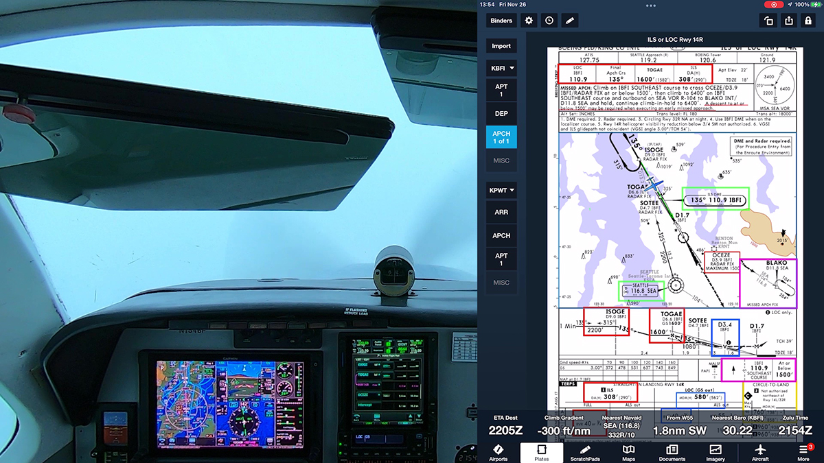
Contrast the view at KCLS with the scene at Boeing Field (KBFI) in Seattle during the final stages of an ILS approach.

ILS RWY 14R at Boeing Field (KBFI)

Here’s an approach to runway 20 at Bremerton, WA (KPWT). KPWT is a non-towered airport, but runway 20 is served by an ILS approach, which includes an ALS.

KPWT
RNAV RWY 20 approach at KPWT

So, regardless of the type of approach you’re flying, make sure you review and prepare for the runway environment that you’ll encounter when you break out of the clouds and go visual. It’s especially important to know which of the visual cues described by 14 CFR §91.175 Takeoff and landing under IFR will be available.

Calling ATC for an IFR Clearance

The weather was barely VFR at Chehalis, WA (KCLS) for this night takeoff, so I called Seattle Center on the phone to get my IFR clearance and release for a flight back to Boeing Field (KBFI).

In 2019, FAA finished publishing ATC telephone numbers in the Chart Supplement, so you can get an IFR a clearance (or cancel IFR) directly with ATC, not via FSS, when operating at a non-towered airport or when a tower is closed.

You can listen to this process at the beginning of the video below and then follow along as I fly the ILS RWY 14R at Boeing Field (KBFI).

The audio panel/intercom in the A36 Bonanza supports a Bluetooth connection to my phone, so I’m able to speak and hear through my headset during phone calls. That feature makes it especially easy to contact ATC, in this case Seattle Center.

Video: KBFI to KHQM at Dusk

I made a short flight from Seattle to the Washington coast at dusk to fly an RNAV (GPS) approach at KHQM. We were between weather systems, but I enjoyed an interesting sky and a sweeping view of the Seattle area after takeoff. Notice also the wispy ground fog in the valleys and the serene scene Hoquiam at the end of the day.

Enroute to KHQM

Formation Practice

Here are clips from a recent formation practice flight out of Boulder City, NV (KBVU). I was in my Extra 300L flying as wingman to lead in his RV-6A. Lead is a fomer Air Force fighter pilot and instructor who has been my primary mentor for formation flying.

First, basic practice flying off lead’s wing.

Next, pitch-outs and rejoins.

Finally, close- and extended trail. Extended trail is a lot of fun.

Minimum Operational Network (MON) Airports

The FAA publishes lists of airports that have ILS and VOR approaches designated as backups if the GPS system is disrupted. These MON (minimum operational network) airports are part of FAA’s plans to decommission about 30% of the existing network of VORs by 2025. The MON airports are not the only airports that offer ILS or VOR approaches. But the procedures at MON airports do not include PBN elements (i.e., GPS).

As the FAA’s MON program website notes:

The VOR MON is further designed to allow aircraft to proceed to a MON airport where an ILS or VOR approach procedure can be flown without the necessity of GPS, DME, ADF, or Surveillance. Of course, any airport with a suitable instrument approach may be used for landing, but the VOR MON assures that at least one airport will be within 100 NM.

The AIM adds:

Any suitable airport can be used to land in the event of a VOR [sic: GPS] outage. For example, an airport with a DME−required ILS approach may be available and could be used by aircraft that are equipped with DME. The intent of the MON airport is to provide an approach that can be used by aircraft without ADF or DME when radar may not be available.

AIM 1-1-3 (f)

Lists of MON airports are sorted by state, which can be misleading at first glance. The state boundaries aren’t especially important–the intent is to provide a MON airport within 100 nm. And even if a widespread GPS outage occurs, you could probably get ATC assistance to find a suitable airport with weather above LIFR minimums. MON airports are truly “last resort” airports.

MON airports are shown on IFR en route charts. See New Airport Info on FAA IFR Charts. More information about the VOR MON program and MON airports is in AIM 1-1-3 (f) VHF Omni-directional Range (VOR). See also this Charting Notice from May 28, 2019.

You can find lists of current MON airports in the Chart Supplement (formerly called the A/FD) books for various regions of the U.S. For example, here is the list of MON airports in the Northwest.

Chart Supplement Northwest Cover
Chart Supplement TOC
MON airports in the Northwest

RNAV Approach at KCLS

I flew an RNAV (GPS) approach at Chehalis, WA (KCLS) to show how low LPV minimums can take you, even to a runway at a typical small-town, non-towered airport that doesn’t have approach lights and other components associated with precision approaches. I flew this procedure in VMC to help you see the runway environment.

Now, an RNAV (GPS) approach to LPV minimums isn’t technically a precision approach, at least according to the current ICAO definition of the term. But as a practical matter, flying to a localizer performance with vertical guidance DA is just like flying an ILS. The lateral guidance funnels you toward the runway, just like a localizer, and the glidepath generated by the GNSS box in the panel acts just like an ILS glideslope. In fact, I prefer flying an LPV approach even when an ILS is available. You don’t have to switch navigation sources, there are no false glideslopes, and there is no ILS critical area.

If the runway served by the RNAV (GPS) approach doesn’t also have an ILS, you probably won’t see approach and runway lights except for edge lighting. And the minimums (DA and visibility) will be a little higher than they would be for a typical category 1 ILS (i.e., 200-1/2). At KCLS, the LPV minimums are 300 AGL (DA 476) and 1 mile.

But those minimums are a substantial improvement over the LNAV MDA (900 MSL; 724 AGL), the lowest you can go without the approved vertical guidance available with WAAS.