
To learn how bearing pointers can help you develop and maintain situational awareness, follow this link to my article in the September 2023 issue of AOPA Pilot magazine.

To learn how bearing pointers can help you develop and maintain situational awareness, follow this link to my article in the September 2023 issue of AOPA Pilot magazine.
The September 8, 2022 edition of the Aeronautical Chart User’s Guide notes that:
Beginning with the September 8, 2022, publication date, all Standard Service Volume designations will be shown for VOR, VOR/DME, VORTAC, DME, and TACAN NAVAIDs on both the IFR Enroute Low and High Attitude charts.
Publishing this information is part of the FAA plan to implement the Minimum Operational Network (MON) of VORs (see also AIM 1-1-3-f), which will leave some 589 VORs still in operation after the program is complete, now scheduled in FY2030.
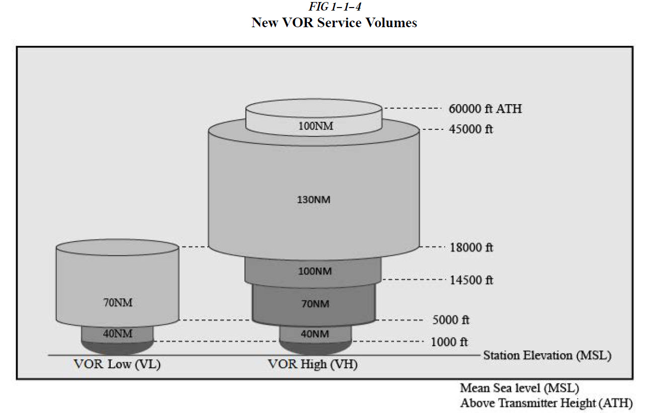
As the FAA decommissions VORs, mostly in the East and Midwest, it is expanding the service volumes of the navaids to help ensure signal coverage for aircraft not equipped with GPS or during GPS outages. The table below, from the Aeronautical Chart User’s Guide, shows both the new service volumes and the codes used on IFR charts to identify the service volume associated with each VOR.

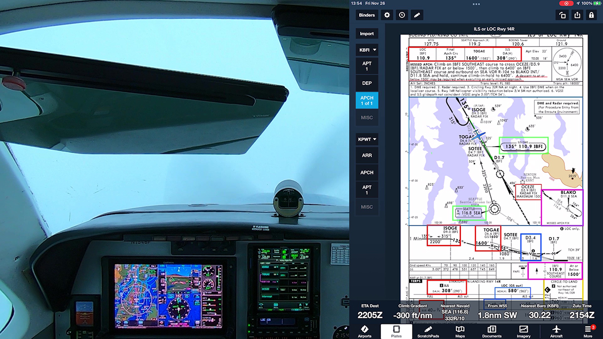
Here’s a section of a low-altitude IFR chart that shows navaid information boxes with some of the new standard service volume classifications.

You can find more information about the new VOR service volumes in AIM 1−1−8. NAVAID Service Volumes.

The October 7, 2021 edition of the Aeronautical Chart Users’ Guide notes that IFR en route charts now show expanded VOR standard service volumes that are being implemented to support the minimum operational network (MON). That network is a key part of the FAA plan to reduce the number of ground-based navigation aids (for more information see Latest on VOR Decommissioning and related posts here at BruceAir).
The new ACUG includes the following note:
IFR ENROUTE CHARTS
Two new VHF Omnidirectional Radio Range (VOR) standard service volumes (SSV) have been implemented in order to achieve VOR service within 70 nautical miles above 5,000 feet above ground level (AGL). The new NAVAID codes are VOR Low (VL) and VOR High (VH). Along with that effort, two new distance measuring equipment (DME) SSVs of DME Low (DL) and DME High (DH) have been implemented to support DME-DME RNAV service. Legacy SSVs of Terminal (T), Low (L), and High (H) will continue to be maintained.
In the past, NAVAIDs at one location typically all had the same SSV. For example, a VORTAC typically had a High (H) SSV for the VOR, the TACAN azimuth, and the TACAN DME, or a Low (L) or Terminal (T) SSV for all three. A VOR/DME typically had a High (H), Low (L), or Terminal (T) for both the VOR and the DME. A common SSV may no longer be the case at all locations. A VOR/DME, for example, could have an SSV of VL for the VOR and DH for the DME, or other combinations.
See Charting Notice ENR_21-01_CN_SSV_Codes for more information.
Sample VOR/DME NAVAID box with two SSVs:

I’ve provided many updates on the FAA program to decommission about one-third of the VOR network in the Continental U.S. That VOR Minimum Operational Network (MON) will leave 589 VORs in operation by FY2030.
FAA recently hosted a webinar to update aviators on the program. You can watch the video below.
Here’s a link to the most recent update on the VOR MON:
Latest on VOR Decommissioning (May 2021)
See also:
Thanks to John Collins, an avionics expert and colleague of mine, I recently learned about feature that Garmin seems to have added to the GTN Xi series navigators and the G500/600 TXi flight displays.
Update: This feature is now documented in the latest GTN 750Xi Pilot Guide (190-02327-03 Rev. D). VOR+V Approaches (p. 3-135) explains that:
Per guidance provided in AC 90-108 regarding the use of GPS as an alternate means of navigation, VOR and NDB approaches may be treated as LNAV+V approaches (i.e., LNAV with advisory vertical guidance) as long as the pilot monitors the VOR.
During approach selection, “+V” displays for VOR and NDB approaches when advisory guidance is available. Approach strings remain unmodified when no vertical guidance is available.
If the approach indicates “VOR+V,” then advisory vertical guidance may be removed without indication. This is due to the vertical guidance not being within tolerances. This does not constitute a downgrade. You may still fly the approach to VOR minimums. Flying a VOR approach with advisory vertical guidance (VOR+V) does not change how the approach should be flown. The pilot is still responsible for descending to the correct altitude at each step down. The result is still an MDA and missed approach point.

FAA updated the AIM and other guidance a few years ago to allow you to “fly the magenta line” along the final approach course of a VOR or NDB approach, if the navaid is working and you can monitor the course with a CDI or bearing pointer.
Note that with GTN Xi software version 20.30 and later, descriptions of VOR/DME, VOR, NDB/DME, NDB, and TACAN approaches with advisory vertical guidance now show “+V” instead of “LNAV+V.”
I’ve explained the details and shown examples of this technique in several posts here at my blog and in a video presentation and a webinar about using GPS while flying conventional procedures and routes:
But now the Garmin GTN Xi units, and I assume their siblings, the GTX and latest GPS navigators, have added advisory vertical guidance, even to VOR approaches. To my knowledge, this feature hasn’t been documented in Garmin manuals or other sources, and it’s not clear to me which minimum hardware and software combinations support this feature.
To test the feature on a fine VFR day in an airplane, I hopped from Boeing Field (KBFI) in Seattle to nearly Olympia, WA (KOLM) to fly the VOR RWY 35 approach.
Ride along with me in this video to see this feature in action.
Here’s the latest information about the FAA program to decommission about 34 percent (307) of the VOR navaids in the U.S. by fiscal year 2030, leaving 589 VORs in the system. That plan includes establishing a minimum operational network (MON) of navaids and airports. The details are in an update (PDF) delivered at the April 26-29, 2021 session of the Aeronautical Charting Meeting.
You can find more information about the FAA plan in previous updates here at BruceAir:
You can also watch video of an FAA webinar about the MON program on YouTube:

Here’s a summary of the next sets of VORs to be shut down. To see the VOR locations on aeronautical charts at SkyVector.com, click the navaid ID links.
Discontinue six (6) VORs – June 17, 2021:
Discontinue six (6) VORs – August 12, 2021:
Discontinue five (5) VORs – October 7, 2021:
FAA also plans to expand the service volumes of the remaining VORs and DMEs to support the MON.

The December 31, 2020 edition of the AIM is out. This edition includes only a few updates, but section 1−1−8 NAVAID Service Volumes, provides a detailed explanation of new navaid standard service volumes (SSV) for VORs and DME, largely to support the change to performance based navigation (PBN).
Paragraph (a) of the section explains that:
The FAA publishes Standard Service Volumes (SSVs) for most NAVAIDs. The SSV is a three−dimensional volume within which the FAA ensures that a signal can be received with adequate signal strength and course quality, and is free from interference from other NAVAIDs on similar frequencies (e.g., co−channel or adjacent−channel interference). However, the SSV signal protection does not include potential blockage from terrain or obstructions. The SSV is principally intended for off−route navigation, such as proceeding direct to or from a VOR when not on a published instrument procedure or route. Navigation on published instrument procedures (e.g., approaches or departures) or routes (e.g., Victor routes) may use NAVAIDs outside of the SSV, when Extended Service Volume (ESV) is approved, since adequate signal strength, course quality, and freedom from interference are verified by the FAA prior to the publishing of the instrument procedure or route.
Details follow in paragraph (2):
With the progression of navigation capabilities to Performance Based Navigation (PBN), additional capabilities for off−route navigation are necessary. For example, the VOR MON (See paragraph 1−1−3 f.) requires the use of VORs at 5,000 feet AGL, which is beyond the original SSV ranges. Additionally, PBN procedures using DME require extended ranges. As a result, the FAA created four additional SSVs. Two of the new SSVs are associated with VORs: VOR Low (VL) and VOR High (VH), as shown in FIG 1−1−4. The other two new SSVs are associated with DME: DME Low (DL) and DME High (DH), as shown in FIG 1−1−5. The SSV at altitudes below 1,000 feet for the VL and VH are the same as FIG 1−1−3. The SSVs at altitudes below 12,900 feet for the DL and DH SSVs correspond to a conservative estimate of the DME radio line of sight (RLOS) coverage at each altitude (not including possible terrain blockage).
TBL 1−1−1, SSV Designator Altitude and Range Boundaries, and a couple of figures provide the details. ATH=Above Transmitter Height.
| SSV Designator | Altitude and Range Boundaries |
|---|---|
| T (Terminal) | From 1,000 feet ATH up to and including 12,000 feet ATH at radial distances out to 25 NM. |
| L (Low Altitude) | From 1,000 feet ATH up to and including 18,000 feet ATH at radial distances out to 40 NM. |
| H (High Altitude) | From 1,000 feet ATH up to and including 14,500 feet ATH at radial distances out to 40 NM. From 14,500 ATH up to and including 60,000 feet at radial distances out to 100 NM. From 18,000 feet ATH up to and including 45,000 feet ATH at radial distances out to 130 NM. |
| VL (VOR Low) | From 1,000 feet ATH up to but not including 5,000 feet ATH at radial distances out to 40 NM. From 5,000 feet ATH up to but not including 18,000 feet ATH at radial distances out to 70 NM. |
| VH (VOR High) | From 1,000 feet ATH up to but not including 5,000 feet ATH at radial distances out to 40 NM. From 5,000 feet ATH up to but not including 14,500 feet ATH at radial distances out to 70 NM. From 14,500 ATH up to and including 60,000 feet at radial distances out to 100 NM. From 18,000 feet ATH up to and including 45,000 feet ATH at radial distances out to 130 NM. |
| DL (DME Low) | For altitudes up to 12,900 feet ATH at a radial distance corresponding to the LOS to the NAVAID. From 12,900 feet ATH up to but not including 18,000 feet ATH at radial distances out to 130 NM |
| DH (DME High) | For altitudes up to 12,900 feet ATH at a radial distance corresponding to the LOS to the NAVAID. From 12,900 ATH up to and including 60,000 feet at radial distances out to 100 NM. From 12,900 feet ATH up to and including 45,000 feet ATH at radial distances out to 130 NM. |

FAA continues its program to decommission about 307 (34%) of the VORs in the continental U.S. Some 589 VORs (with enhanced service volumes) will remain operational when the minimum operational network (MON) program is complete, now scheduled for FY2030.

At the October 2020 session of the Aeronautical Charting Meeting, Ernesto Etienne, VOR MON Lead Engineer at FAA, provided an update on the program to date.
For more information about the MON program, see: Updated VOR Retention List, Next Round of VOR Shutdowns, VOR Status–Another Update, Minimum Operational Network (MON) Airports.
As of September 20, 2020, FAA had shut down 82 VORs. In Phase 2 of the program, which runs through FY2030, another 225 navaids will be decommissioned.

The 82 VORs discontinued as of September 30, 2020 are in this list (PDF).
Through the end of calendar year 2020, the following navaids are scheduled to be shut down (to see these VORs on a chart at SkyVector, click the links).
Five (5) VORs planned for discontinuance – November 5, 2020:
Many IFR pilots and instrument students overlook the VOR equipment test required every 30 days by 14 CFR 91.171.
The 6 minute presentation below explains the details of the rule and how you can conduct a VOR test using one of the approved methods.
FAA is in the midst of a years-long program to decommission about one-third of the VORs in the National Airspace System (NAS). Most of the VORs on the shutdown list are in the eastern two-thirds of the continental U.S. The remaining network, known as the Minimum Operational Network (MON), will still contain nearly 600 VORs.

The latest list of VORs that FAA intends to keep (dated June 2020) is available as a Microsoft Excel worksheet on the FAA website, here.
More information about the plans to decommission VORs is available at the following posts:
Minimum Operational Network (MON) Airports
Next Round of VOR Shutdowns
VOR Status–Another Update
