Flying an Approach with only an iPad

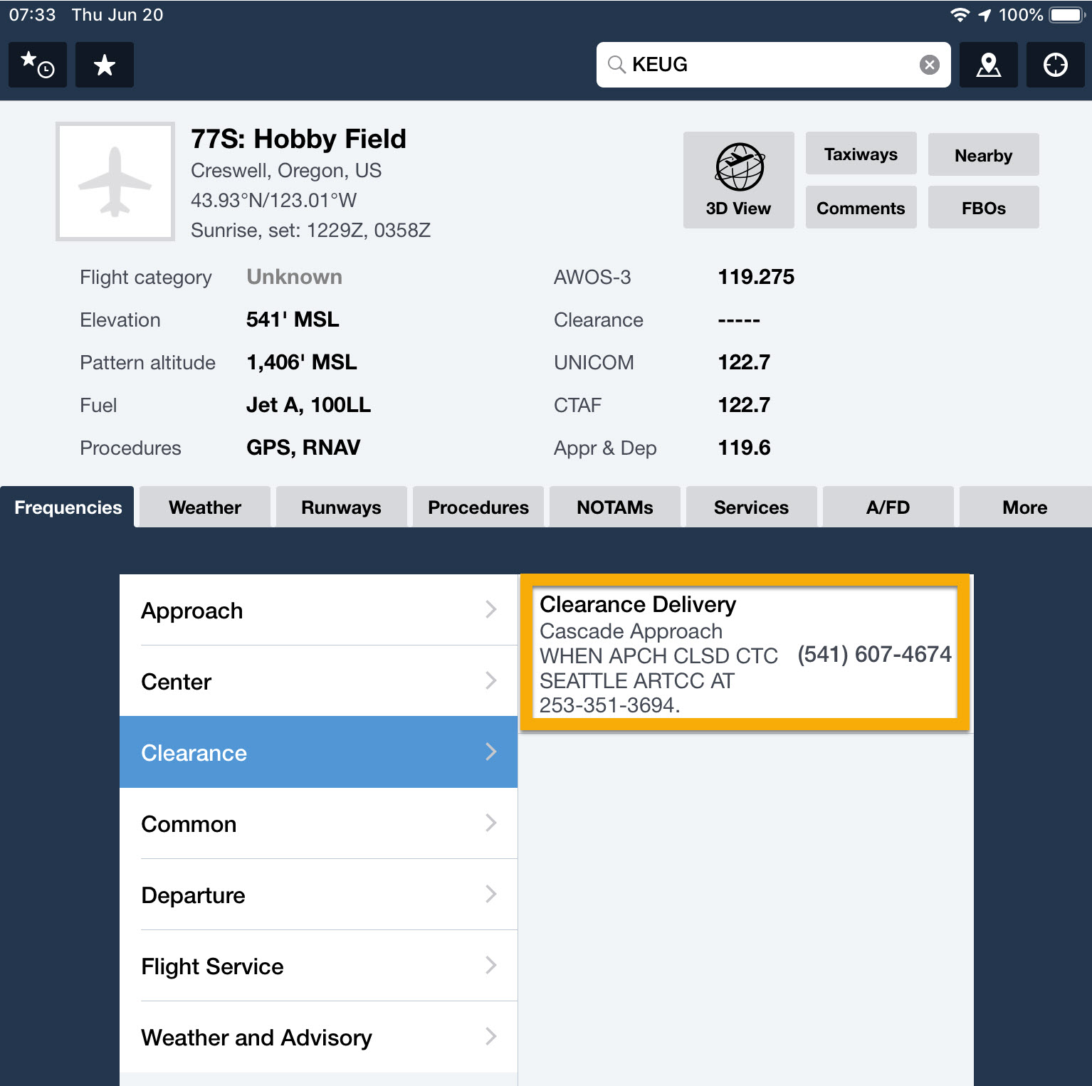
You’re suddenly having a bad IFR day. As you approach your destination, Huron, SD, after a routine departure and a comfortable cruise in IMC, most of your panel abruptly goes dark. You still have basic flight instruments, including an electronic PFD and an HSI, which run on backup batteries. Your last communications with ATC included a clearance to an initial approach fix and “expect the ILS RWY 12 approach.” But your GPS navigator, which includes navigation receivers, is now kaput, along with your second nav/com. In other words, you have no moving map or course guidance in the panel–just attitude, airspeed, altitude, and heading. You can’t even see a GPS track indicator.

The good news is, you have an iPad with a built-in GPS (or a tablet connected to an external GPS source) running ForeFlight or a similar app. The EFB confirms that your blue “own ship” symbol is tracking toward HUMSO, an initial approach fix that marks the beginning of a feeder route that takes you to the final approach course.

Using just your track shown on the approach chart, and your basic instrument flying skills, can you fly the approach?

See my article on this topic at AOPA Flight Training magazine: When the Screens Go Dark.

I practice such scenarios periodically during recurrent training. In my A36 Bonanza, operating under VFR with a safety pilot, I switch the navigation screen on my GTN 750Xi to the traffic page, which provides no navigation information, and then I practice getting to an airport and flying an approach using only the iPad for guidance.

Of course, an iPad isn’t a “suitable RNAV system” as defined in the AIM and FAA advisory circulars, but in IMC under IFR, this scenario qualifies as an emergency, and you can bend the rules as necessary to arrive safely.

As you’ll see in this video, a challenge like this is also an excellent workout in an aviation training device. Galvin Flying, the flight school in Seattle where I instruct, has two ATDs made by one-G Simulations. They emulate C172s. You can connect ForeFlight to the Wi-Fi signals broadcast by each trainer, which send position, altitude, speed, and other information to your tablet. As far as ForeFlight is concerned, you’re flying.

Just as in the airplane, provided your EFB can receive GPS signals, you have a good 2-D navigation solution. If you can keep your blue airplane tracking along the lines on a geo-referenced approach chart, you’ll follow the intended path. What you don’t get, however, is any type of vertical guidance. It’s up to you to establish and maintain a steady descent that keeps you as close as possible to an ILS glideslope or a GPS glidepath for an approach to a DA, or to the profile for a non-precision approach to an MDA.

You may also want to practice using the synthetic vision feature, if your EFB app supports it. Although I prefer flying with the procedure chart visible, synthetic vision would be a terrific aid if you lose the basic flight instruments.

Flying an approach like this successfully requires mastery of fundamental instrument skills, what we used to call flying with only “needle, ball, and airspeed.” You must understand and be able to apply the control-performance method of instrument flying—establishing the appropriate attitude, setting power and configuration, monitoring your progress, and making constant, smooth adjustments as you proceed. In other words, it’s a good test that takes you back to drills like flying Pattern A and Pattern B that you practiced early in your IFR training.

Watch the video to see how accurately I flew two approaches in the ATD with just the airplane symbol on an approach chart for guidance.

‘Expected Route’ v. ‘Cleared as Filed’ in ForeFlight

When you file a flight plan with ForeFlight, the app confirms that your flight plan was accepted or notifies you if there’s a problem with the information that you sent to ATC. Typically a few moments after you send the flight plan, ForeFlight displays a follow-up message that includes the “expected” route received from the ATC computer. If the expected route matches what you filed, the message from ForeFlight includes the words “as filed.”

It’s important to understand that “as filed” means what the words say–the route that you specified when you filed your IFR flight plan. The expected route may be something different–and it may not be the route that clearance delivery or another controller issues when you call for your official ATC clearance.

If you’re aren’t sure of the route ATC expects you to fly, ask for a full-route clearance.

ForeFlight has explained the process and terminology in various posts and sections of the Pilot’s Guide. For example, ForeFlight posted the following on Facebook on February 23, 2018:

We recently updated our Expected Route notifications and emails to indicate when your expected route is the same as the one you filed. Look for the “(as filed)” note next time you file with ForeFlight!

See also this explanation from ForeFlight from November 4, 2021.

Cleared as Filed vs Expected Route

Cleared as Filed – This means the routing will be what the pilot originally filed in their flight plan (or as later amended) and does not relate to an expected clearance. Routing that is “cleared as filed” is an ATC function.

Expected Route -We provide Expected Route notifications when we receive them from the ATC systems. You can elect to ignore or accept the “expected route”.

If you ‘Accept’ the Expected Route in the push notification, please be aware that the Expected Route is only a notification – your originally filed flight plan is what ATC expects you to fly if they issue you a clearance of “as filed”. “Accepting” the expected route simply updates your Flight form in ForeFlight Mobile such that the proper performance numbers can be calculated.

The current edition of the ForeFlight Pilot Guide (v13.10) includes the following:

Meaning of Abbreviated Clearance: “Cleared as Filed”
ATC can issue either a full route clearance, or an abbreviated clearance such as “Cleared as filed” or an initial route followed by “…then as Filed”.! SIDs are excluded from “Cleared as filed” clearances, and can be added or changed from the SID in the filed route. In that case ATC can still issue the new SID and “Then as Filed”.

It is very important not to mistake the “Expected Route” as the “Filed Route”. The “Filed Route” is always what the pilot originally filed in the flight plan. If a pilot mistakes the “Expected Route” as the “Filed Route” and ATC issues the clearance as “Cleared as Filed” (as often happens)!the pilot may end up flying the wrong route.

For example, if a pilot files a direct route from the departure airport to the destination airport and the ATC computer generates a route with a dog leg to a fix in the route, ForeFlight Mobile relays that in an expected route. The pilot contacts ATC for the clearance and the actual clearance is “As Filed”. The controller is assigning the filed direct route and not the computer generated expected route. In this case, the expected route is not used. (p. 293)

An Overlooked ForeFlight Feature: “Instruments”

In my experience flying with students and a wide range of other pilots, I’ve noticed that most pilots haven’t customized the information fields at the bottom of the map page in ForeFlight (the most popular electronic flight bag (EFB) among general aviation pilots).

ForeFlight calls these six fields the Instrument Panel, and like the gauges and avionics installed in the aircraft’s instrument panel, the blocks of information can show you a variety of information, updated in real time (if your tablet has an internal GPS or is connected to a GPS) that complements data from the panel. Even if you fly only VFR in a basic airplane, the ForeFlight instruments can provide constant updates, for example, of your position relative to a VOR.

Other EFB apps, such as Garmin Pilot and FlyQ, offer a similar feature. For the details, see the guide for the app that you use.

I typically display a set of information that I find useful while flying IFR. I have multiple ways to display current groundspeed, distance to the next waypoint, etc. in the panel, so in ForeFlight I typically show:

  • Flight Time (time since takeoff)
  • ETA at the destination and/or ETE to the destination
  • Current climb gradient (ft/nm)–especially useful during IFR departures
  • ID and bearing/distance information from the nearest navaid (VOR or NDB)
  • Bearing/distance from the nearest airport
  • Nearest altimeter setting (useful for VFR flights)

You can choose from many other options, depending how you fly and the instruments and avionics available in your panel. Foreflight describes the Instrument Panel feature and the options in the Pilot’s Guide. The current list of available instruments appears below.

ForeFlight Instrument Panel Options

To learn more about the Foreflight Instrument Panel, see the Pilot’s Guide to ForeFlight Mobile 

Microsoft Flight Simulator 2020 and ForeFlight

Sporty’s iPad Pilot News has a helpful article about how to connect the new FS2020 to ForeFlight. (You can also find details about using iPads with other PC-based simulations and some ATDs at iPad Pilot News here.)

The process involves using a small utility called Flight Events Client, ensuring that both your iPad and the computer running FS2020 are on the same wifi network, and selecting Flight Events Client as a device in ForeFlight. I have not tested the utility with other EFB apps such as Garmin Pilot.

My tests so far indicate the utility works well, although I did notice that my virtual airplane made occasional jumps into hyperspace before returning to the correct place on the ForeFlight map.

For my initial assessment of using FS2020 to complement flight training and proficiency, see Flight Simulator 2020: First Impressions.

Annotating IFR Charts

Annotating electronic charts makes flying IFR procedures easier and less stressful. The video presentation (below and at my YouTube channel) describes how you can use the markup features in EFB apps such as ForeFlight to highlight important data and consolidate information from several sources so that it’s available on the charts in front of you as you fly.

Annotating charts also helps address a modern problem. EFBs have eliminated the hassle of updating paper charts and related documents.

Today it’s easy to go through many update cycles without really looking at charts you use regularly, to say nothing about procedures you fly only occasionally.

Marking up electronic pages also helps you slow down and review the details on charts. Annotating on the ground reduces heads-down time and confusion in flight, especially for trips outside your normal operating area.

All of the popular EFB apps include an annotation feature. You can learn more about the details for your app at the developer’s website and in the user guides that they publish. Here are some links to get you started:

ForeFlight videos about annotations

Garmin Pilot User Guide

FlyQ Support

iPad Pilot News: How to Mark up Charts in Your Aviation App

For information about pens (styluses) that you can use with an iPad, see Stylus for iPad and ForeFlight ScratchPads and Annotations.

ForeFlight Track Log Review

ForeFlight now includes an enhanced track log that any pilot–but especially flight instructors and pilots in training–will find useful when reviewing and debriefing flights.

The new Track Log Review feature is available in ForeFlight release 11.5. Here’s the ForeFlight video that explains the feature. (ForeFlight has published a series of how-to videos on its YouTube channel.)

ATC Phone Numbers Now in ForeFlight

On June 20, 2019, FAA began publishing telephone numbers that pilots can use to call ATC for IFR clearances and cancelations (see FAA Completes ATC Phone Number Plan). The numbers appear in the airport listings in the Chart Supplement.

Leidos FSS has posted ARTCC clearance/cancelation phone numbers on its website, here.

If you use ForeFlight, you can also find those ATC numbers in the airport listings. As the screen capture below shows, the information is on the Frequencies tab. The number will be either to an approach control facility or an enroute traffic control center, depending on which facility controls the airspace overlying the airport.

ATC Phones_ForeFlight.jpg

ATC_ForeFlight_002

ForeFlight PDF Briefing Format

ForeFlight has added a PDF option for displaying preflight briefings. As the tweet below explains, the enhanced PDF briefing provides a more compact briefing that, among other features, sifts out irrelevant NOTAMs.

ForeFlight-PDF-Briefing-Tweet

The Briefing Format option is on the Settings tab in ForeFlight.

ForeFlight-BriefingFormat

I tested the feature by briefing an IFR flight from Boeing Field (KBFI) in Seattle to Felts Field (KSFF) in Spokane. You can download the full PDF of that briefing here.

The illustrations below show examples of the pages from the briefing.

ForeFlight-PDF-Briefing-P1

ForeFlight-PDF-Briefing-P2

ForeFlight-PDF-Briefing-P3

ForeFlight-PDF-Briefing-P4


Stylus for iPad and ForeFlight ScratchPads and Annotations

ForeFlight, the most popular aviation app for the iOS phones and tablets, includes handy ScratchPad and Annotations features. Both of these features are most useful when you have a stylus that works with the iPad and ForeFlight.

A video that shows the Annotations feature in more detail is also available at YouTube.

I experimented with the ScratchPad the other day as I flew with an IFR customer. It’s a handy feature, with built-templates, but I quickly found that using my stubby index finger to scribble clearances and ATIS data didn’t work well. It was hard to write quickly and clearly.

Off to Amazon I went in search of a stylus designed for iOS devices. After a quick search and scan of customer reviews, I settled on the Bargains Depot pack of two styluses (with six replacement tips), for $5.99. Many other options are available at Amazon, generally at prices well below $10 for packs of 2-5 styluses.

I’ve now tested these tablet-pens with ForeFlight and other apps, and I’m pleased. The tips are soft enough not to damage the screen, but they also make writing on the tablet seem natural. They also work well as pointing devices when you need to tap on a menu or the map, scroll, or close a window.

Another option is the Logitech Crayon, now my preferred note-taking tool. It’s more precise than a soft-tip stylus.

Logitech Crayon

Here are the specs on the Logitech Crayon at the Logitech website.

I like the Crayon because it doesn’t roll around like the Apple Pencil. It’s not as cool, but it’s also substantially less expensive.

Other manufacturers have begun offering styluses that closely resemble the Apple Pencil. These clones emulate the basic Apple Pencil features, although they usually don’t include the pressure and tilt sensitivity that artists want. But they seem fine for taking notes.

I have tried and like the SOCLL 2nd generation stylus available for about $30 from Amazon and other online retailers. Just make sure you get a model that is compatible with the model of iPad that you own.

If you use a tablet or smartphone in the cockpit, I recommend that you keep at least a couple of styluses handy. They’ll never run out of ink.

Flying (and Filing) Direct v. Airways

Most pilots who use GPS as their primary navigation tool, whether operating VFR or IFR, now plan their flights assuming a direct course from departure to destination. They do so for several common reasons:

  • To save time and fuel by trimming miles from long flights
  • To simplify the creation of flight plans (lists of waypoints) in GPS navigators, especially units that don’t support entry of airway designations
  • To simplify navigation in flight by reducing the number of turn points
  • To avoid major changes from a filed IFR flight plan when they receive their actual clearance from ATC. Pilots who file direct often say, “Filing a specific route is futile. ATC assigns a different route when you get your clearance, so why bother planning a detailed route?”
Direct or…

Direct

…Airways?

Airway

While it’s true that direct routes are by definition shorter than those that include zigs and zags, as we’ll see shortly, the difference, especially on trips of the length typically flown by piston-powered aircraft operating below the flight levels, is usually much smaller than most pilots assume.

For more information about routes that I often fly, see Sample Western U.S. Flight Routes. To learn more about T-routes for aircraft equipped with GPS, see New T-Routes in the PNW.

In the event, terrain, airspace, and preferred routes (under IFR) can make direct routes ill-advised, impractical, or impossible, especially in the mountainous regions of the West and within the congested airspace of areas like the Northeast, the Bay Area, and the LA Basin.

A route with several waypoints or which travels at least partially along airways has several advantages, including:

  • Making it easier to track your progress on charts
  • Helping you remain aware of alternatives should you need to stop for fuel, accommodate passengers, avoid weather, or deal with a malfunction

It’s also far easier to amend a flight plan than it is to build a complete flight plan from scratch, and having a detailed route “in the box” before you leave the ramp also helps reduce heads-down time while taxiing and during high-workload phases of flight like departure and arrival, especially when you’re trying to navigate unfamiliar airspace.

(Keep in mind that even if you prefer to file and fly direct under IFR, your route usually must include several waypoints. The procedures and requirements for filing direct and RNAV routes are described in AIM 5-1-8, especially sections C and D.)

But for the purposes of this exercise, assume that direct routes are feasible.

Direct v. airway: distance, time, and fuel

Today, many tools make laying out routes an easy, no-math proposition, so planning a flight with course changes is hardly a chore. Flight-planning/navigation apps like ForeFlight include flight-planning/route-building features that make it easy to compare direct and airway routings and to include preferred and TEC routes, and SIDs and STARs. The flight log features in apps like ForeFlight also help you efficiently build flight plans in GPS navigators (such as the popular Garmin GNS 400/500 series boxes) that require manual entry of at least the fixes that define entry, turn, and exit points of airways or the initial fixes of SIDs and STARs.

Let’s use ForeFlight to explore some of the issues outlined above in more detail.

A typical flight: KBFI-S78

Here’s route between Seattle and Boise that I fly several times a year to support Pilots N Paws. It’s from Boeing Field (KBFI) to Emmett, ID (S78).

As you can see below, the direct route is 327 nm. In this example, at 160 KTAS, estimated time in en route is 02:10, and the trip requires about 32.5 gallons of fuel, not including time and fuel to climb.

020

And climb we must to fly this route, because under IFR we must cruise at or above 10,000 ft. to clear terrain (probably at least 11,000 ft. when flying southeast). The direct route also clips or comes close to a couple of restricted areas.

My typical, mostly airways, route, at 341 nm, is only 14 nm longer, about 5 minutes at 160 knots. This route follows the airway between SEA and ELN (MEA 8000) and clears the big restricted area near YKM. In fact, the total mileage is a bit less, because after takeoff, ATC typically vectors me to join V2. The KBFI-SEA leg is in the flight plan (and the box) just to make it easier to join the airway.

This route also passes near many airports and VORs, giving me options and backup navigation sources.

021

Another common route, via V4 out of Seattle, is, at 330 nm, practically the same as the others, although it requires a cruise altitude of at least 10,000 ft. under IFR.

022

Another example: Seattle to northern California

Here’s another trip that I make a few times a year: KBFI to the Bay Area with a fuel stop (for relatively inexpensive fuel) at KOVE (Oroville, CA). The direct route is 483 nm.

023

That route spends a lot of time over the mountains and clips some MOAs. Because of traffic between Seattle and Portland, ATC isn’t likely to offer it under IFR.

My usual filed route avoids those issues and comes in at 511 nm, a difference of 28 nm (about 10 minutes at 160 knots). It clears the busy corridor between Seattle and Portland, and ATC usually accommodates it. Again, this route remains close to many airports, and the majority of the flight is over terrain that allows reasonable MEAs. Because I have stored this route (including the fixes that define V23) in my GNS530W, it’s easy to include changes or shave miles if ATC approves shortcuts (e.g., between OLM and EUG) or deviations for weather. But as we’ve seen, on trips of this length, trimming a leg or two doesn’t typically offer significant savings in time or fuel.

024

One more example: KBFI-KOSH

But what about a much longer flight, say the annual trip to EAA AirVenture in Oshkosh, WI? Leaving aside the need to stop for fuel and spend the night, the direct route from KBFI to KOSH is 1,417 nm, about 08:38 of flying time at 160 KTAS.

028

A typical, mostly airway route (subject, of course, to changes for weather) is about 100 nm (some 7 percent) longer, but it adds less than 1 hour of flying time (winds aloft and other factors being equal). Total block time, of course, would be much greater to accommodate fuel and overnight stops, but those considerations also apply to the direct route.

029

More importantly, the mostly airways route guides you through mountain passes and keeps you relatively close to airports and highways (which means you’re also nearer towns and services).

Flight plans and flight planning

As I’ve suggested above, filing and filing a route that includes airway segments and multiple waypoints can also help you track your progress more easily than when following long direct segments. The act of laying out a route and building a flight log encourages you to become familiar with navigation fixes and to think about decision points along the way. What’s the weather like at nearby alternates? Which airports offer the best services? What types of instrument approaches are available along the way? What are good points en route to evaluate your actual flight time and fuel burn?

It’s certainly possible to ask and answer such questions when laying out a basic direct route, but there’s often real value—and little additional cost in time or money–in following another path.