As of August 27, 2019, FAA requires that all flight plans (VFR, IFR, domestic, and international) use the ICAO format.
Most pilots file flight plans electronically, typically via an app or website such as ForeFlight, Garmin Pilot, or Fltplan.com, so many of the details of the ICAO plan form (electronic or on paper) aren’t important. Fill in the basic information such as departure, route, destination, and ETD, and the apps and websites ensure that data are formatted correctly.
The most difficult hurdle for pilots new to the ICAO format is figuring out the correct codes and other details about the aircraft that you fly. But once you enter the information about the aircraft into the app(s) that you use, filing ICAO is trivial.
A detailed explanation of the ICAO flight plan form is available here. Flight Service also has a handy tip card here and more details, including links to videos, here. AC 90-114-Automatic Dependent Surveillance-Broadcast Operations also offers several important details.
In November 2013, FAA updated and simplified some of the requirements for filing ICAO flight plans for domestic use. You can read about those changes here (PDF). Note that the instructions from FAA focus on the printed flight plan form, which few pilots use. Apps such as ForeFlight, Garmin Pilot, WingX, FltPlanGo, go FlyQ take care of many of the details for you. You should review the user guides and other instructions for the apps and web-based tools that you use to file flight plans. ForeFlight has detailed information about ICAO flight plans here.
Confusing Codes
Many pilots are confused by elements of the ICAO flight plan format, especially the multiple aircraft equipment codes that you must include to inform ATC of the gizmos and capability that are installed in your aircraft.
The following guide should help you sort out those ICAO codes if you fly a typical light GA aircraft equipped with at least one WAAS-capable, GPS navigator that is approved to fly RNAV (GPS) approaches. Examples of such avionics include:
Garmin has posted detailed information about the ICAO codes for its avionics.
Overview
Here’s a look at the relevant parts of the ICAO flight plan form as shown on the Leidos FSS website. You can find a video that describes the ICAO flight plan form at Leidos FSS here.
I’ve filled in the information for my Beechcraft A36 Bonanza (ICAO identifier BE36), which is equipped with a GTN750, a Garmin GTX 327 transponder (not Mode S), and the GDL 88 ADS-B transmitter and receiver. This aircraft also has a Bendix/King DME receiver.
For more information about the ICAO identifiers to use for the makes and models of aircraft that you fly, see ICAO Aircraft Type Designators here at BruceAir.
The example is for an IFR trip from KBFI to KGEG in the Pacific Northwest. The route includes the ZOOMR1 STAR into KGEG.

Basic Information
The first few items are the same for all typical IFR general aviation flights:
- Flight Rule: IFR
- Flight Type: G (for general aviation)
- Number of Aircraft: 1 (i.e., not a formation flight)
- Wake Turbulence Category: L (for light)
- Aircraft Type: The official ICAO designator for the make and model of aircraft you fly (e.g., BE36, C172, C210, M20P, PA28A, etc.)
Aircraft Equipment
On the familiar FAA domestic flight plan form, equipment suffixes for typical GA pilots are simple, and if you’re flying a GPS-equipped airplane with a Mode C transponder, the basic /G was all you needed.
But the ICAO form captures many more details about the equipment installed in your aircraft, and the fun typically begins with this item.
For a WAAS-equipped aircraft such as we’re discussing, you should enter the following codes in the Aircraft Equipment box:

As you can see in the illustration from the Leidos FSS web form, these letters represent the following equipment:
- S: Standard communication and navigation receivers/transmitters (VOR, VHF communications radios, and ILS receiver). If you enter S in this box, you shouldn’t include the letters L (ILS), O (VOR), or V (VHF) here. S includes that equipment.
- B: LPV approach capability. If you have a WAAS GPS, but your installation isn’t approved for LPV procedures (see the user’s guide and AFM supplement), omit this letter.
- D: DME. If you don’t have DME, omit the D.
- G: IFR-approved GPS (the preferred term is now GNSS, Global Navigation Satellite System)
- R: PBN approved. This letter means that your aircraft meets basic RNP standards. All aircraft with an IFR-approved GPS are PBN approved (see AIM 1-2-1). You must include R, and associated information in the Other Information box, to ensure that the computer will accept a routing that includes RNAV routes, SIDs, STARs, or charted ODPs. See PBN and RNP Confusion, below.
- Z: Indicates additional information to be added to the Other Information box, described below.
- If you still have an ADF, include F.
PBN and RNP Confusion
The aviation world uses RNP (required navigation performance) for two related, but different purposes.
For more information about RNP, RNAV, and RNP APCH notes on instrument procedure charts, see Unscrambling RNAV, RNP, and Other Chart Naming Conventions and Notes.
In general, RNP is an RNAV specification (e.g., RNAV 5, RNAV 2, and RNAV 1) that indicates that an aircraft is capable of maintaining a course (track) within designated limits 95 percent of the time. For example, RNAV 5 means the aircraft as equipped can reliably maintain a track with 5 nm; RNAV 2 limits are 2 nm, and so forth. If your aircraft is equipped with an IFR-approved GPS authorized to fly RNAV (GPS) approaches, it matches this sense of RNP and PBN.
The basic RNP (RNAV) specifications used in the U.S. (RNP 0.3, RNP 1.0, RNP 2.0, and RNP 1.0) are shown in the following illustration from the Instrument Flying Handbook (FAA H-8083-15B). For more information about RNP and RNAV specifications, see “Required Navigation Performance” on page 9-44 of the IFH.

Current WAAS-approved GPS receivers for typical GA aircraft, such as those listed earlier, meet the U.S. RNP specifications, as described in AC 90-100A: U.S Terminal and En Route Area Navigation (RNAV) Operations and the associated AC 90-100 Compliance document (PDF). To confirm your GPS receiver’s capabilities, check the user guides and the AFM supplements for the equipment installed in your aircraft.
The term RNP is also applied as a descriptor for airspace, routes, and procedures (including departures, arrivals, and IAPs). RNP can apply to a unique approach procedure or to a large region of airspace. In this sense, RNP means something similar to Category II and Category III instrument approaches. For example, an approach with RNP in the title (e.g., RNAV (RNP) Z RWY 16R) requires special equipment and detailed crew training/qualification. Such RNAV (RNP) approaches include the note AUTHORIZATION REQUIRED on the chart.
For more information about RNP approaches, see RNP Procedures and Typical Part 91 Pilots, Unscrambling RNAV, RNP, and Other Chart Naming Conventions and Notes, Garmin Radius to Fix Leg Project Report here at my blog.
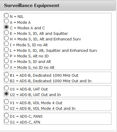
Surveillance Equipment (Transponder and ADS-B)
This box on the ICAO form tells ATC what type of transponder and related equipment are installed in your aircraft.
- For most GA pilots flying IFR, this box will include at least C, for a transponder with altitude-reporting capability.
- If you have a Mode S transponder, you should select the appropriate letter, E, H, I, L, P, S, or X, based on the information in the user guide and AFM supplement for your transponder.
- If you have ADS-B equipment installed (not a portable ADS-B receiver such as the Stratus or Dual XGPS170), include U1 or U2. The Garmin GDL 88 in my airplane both transmits and receives ADS-B signals, so I add U2 to this box.
Other Information
The final box for designating your RNAV capabilities and additional data is Other Information. You must use prefixes, followed by letters, to include different categories of information.
As described above here and here, it’s important to add a PBN/ group in this box to ensure that the ATC system understands the RNP/RNAV capabilities of your aircraft.

If you have a GPS approved for at least IFR en route and terminal operations, add the following letters:
- C2, which designates RNAV 2 capability based on GPS (GNSS)
- D2, which designates RNAV 1 capability based on GPS (GNSS)
If you have a Mode S transponder that complies with the ADS-B out requirements, add the following group to this box:
If you have a UAT box such as the Garmin GDL 88 to meet the ADS-B requirements, add the following group to this box:
You should also file the six-digit Mode S Code (base 16 / hex) assigned to your aircraft by inserting a CODE/ group. You can find the hexadecimal code for your aircraft by checking the FAA N-number registry:
For example, the code for one of the aircraft at the flight school where I instruct is A66E8E. The entry for that aircraft is:
For more information about the filing the appropriate codes related to ADS-B capabilities, see Filing for Advanced Surveillance Broadcast Capability (PDF) at the FAA flight plan website.
You can also add a NAV/ group in this box to indicate your RNAV capability. This group isn’t necessary if you use the appropriate PBN codes described above. But you can use a NAV/ group such as D1E2A1to indicate that you have RNAV 1 capability for departure, RNAV 2 capability for the en route segment, and RNAV 1 capability for arrival.
These groups and letters mean that you can fly RNAV routes (e.g., T-routes), RNAV SIDs and STARs, and charted ODPs (charted ODPs are often RNAV procedures, usually based on GPS).
For more information about charted ODPs, see:
Don’t worry about the options in the RNP Specifications part of this box. Unless you are authorized to fly RNAV (RNP) procedures (see above), these items don’t apply to you.
Summary
Here’s a quick review of what to put in the equipment-related boxes of the ICAO flight plan form if, like me, you fly an aircraft with one of the common IFR-approved, WAAS-capable GPS receivers:
- Aircraft Equipment: SBGR
- Surveillance Equipment: C (for a Mode C transponder).
(If you have ADS-B in/out capability, such as a Garmin GDL 88, add U2. If you have a Mode S transponder, include the appropriate letter for your model.)
- Other Information: PBN/C2D2 SUR/260B or SUR/282B and CODE/xxxxxx
(where xxxxxx is the six-digit hexadecimal code assigned to your aircraft as part of its registration record at the FAA).


