New Garmin GTN 750 Features

Garmin has released system software 6.50 (since updated to 6.51, which is a mandatory update) for its GTN 750 and GTN 650 navigators. The new software adds several features, including:

  • Vertical navigation (VNAV) capability when flying STARS and the initial stages of instrument approaches
  • Along-track offsets in flight plan segments
  • Destination airport remains in the flight plan when an approach is loaded (but the destination airport is removed when the approach is activated)
  • A shortcut to the airport info page added to all procedure headers
  • Load the approach NAV frequency from the approach header in the flight plan
  • QWERTY keyboard option

The following sections highlight some of these features. For more details on how to use the functions, see the latest editions of the GTN guides, available in my Aviation Documents folder at OneDrive and from Garmin’s product pages.

The details about this update to the GTN series are in ASDN Service Bulletin 1860, the 6.51 mandatory udpate, and the GTN 725/750 SOFTWARE v6.50 PILOT’S GUIDE UPGRADE SUPPLEMENT.

Garmin also released system software updates for the G500/600 PFD/MFD and associated hardware. For details on those updates, see ASDN Service Bulletin 1861.

Garmin has also updated its free Windows-based trainer for the GTN series.

Note that these system updates must be performed by an authorized Garmin dealer or avionics shop unless you are flying a experimental-homebuilt aircraft.

VNAV Capability

The new software adds several vertical navigation features, best illustrated with examples.

Garmin has published a video that describes the VNAV feature in detail, here.

Suppose you are flying the RNAV RWY 08 approach at Lewiston, ID (KLWS), joining the procedure at the BIDDY initial approach fix northwest of the airport. The NoPT feeder route from BIDDY specifies an an altitude of at or above 5000 ft to EVOYU, followed by a descent to at or above 4000 ft to MABIZ, and then at or above 3400 ft to the FAF at GIYES.

KLWS-RNAV-RWY08

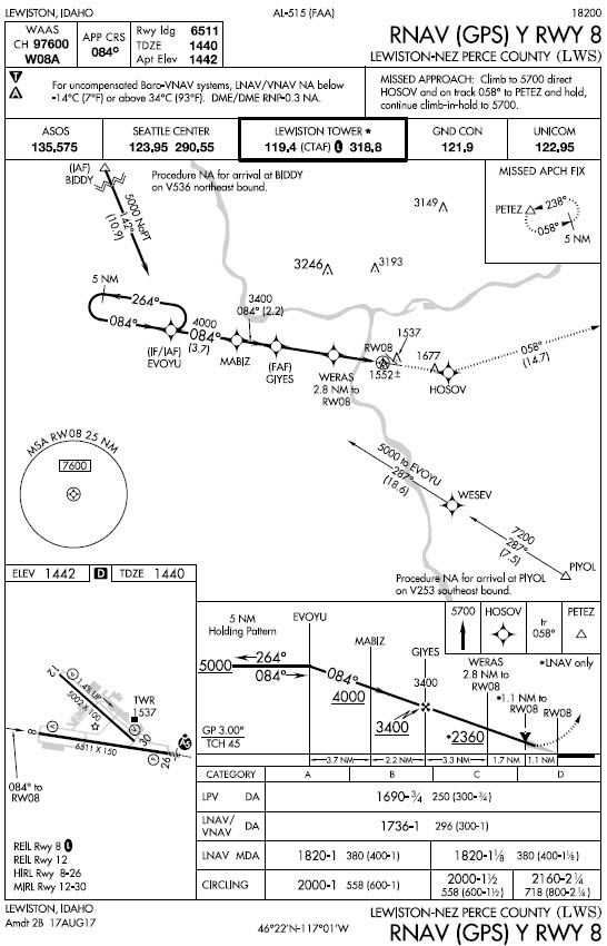
With the new GTN system software, those segment altitudes appear in the flight plan page for the procedure.

GTN750-KLWS-RNAV08-FltPlan-01
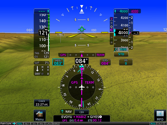
The VNAV feature appears as a magenta vertical guidance cue next to the altitude tape on a PFD such as the new Garmin G500Txi (shown here) or the G500. Note that at this point in the approach, the LPV glidepath is a dim white diamond behind the magenta VNAV cue because the FAF is not the active waypoint and LPV is not yet annunciated on the HSI.

The VNAV cue provides advisory guidance to help you smoothly descend to each charted altitude as you fly the initial stages of the approach.

GTN750-KLWS-RNAV08-TXi-01
The LPV glidepath marker that displays approved vertical guidance replaces the VNAV cue when the FAF is active and the GTN system confirms that LPV minimums are available, as shown below.

GTN750-KLWS-RNAV08-TXi-02

Similar VNAV information and cues are available when flying a STAR, such as the MADEE FOUR arrival at Bellingham, WA (KBLI).

KBL-MADEE-4

Note that the altitudes shown in the GTN flight plan list for this STAR are for turbojet aircraft. But you can easily edit the altitude if ATC assigns a more appropriate altitude when you’re flying a typical piston-powered light aircraft.

GTN750-KBLI-MADDEE-4-01

GTN750-KBLI-MADDEE-4-02

If you are flying an approach based on an ILS, LOC, or VOR, you can quickly retrieve the navaid frequency by touching the approach title, as shown below for the ILS RWY 16 at KBLI.
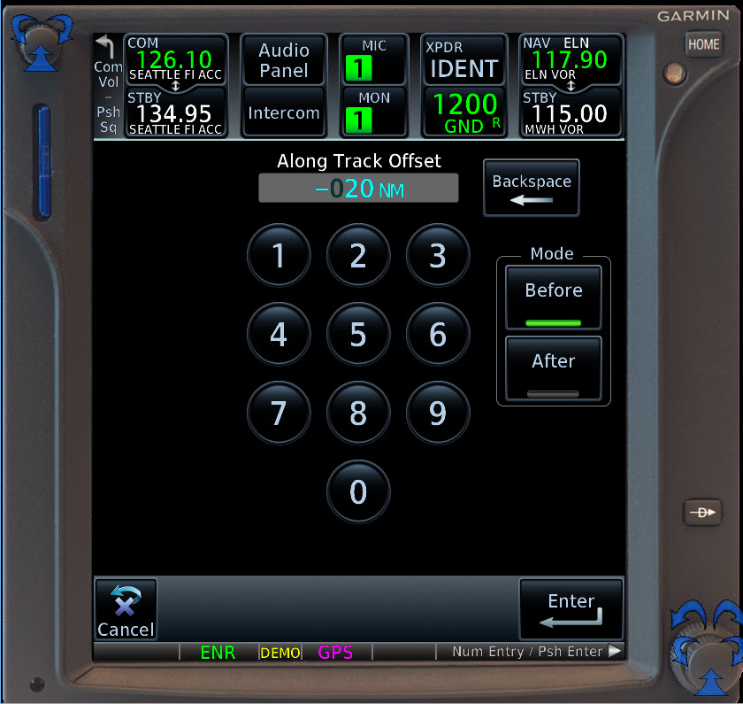
GTN750-KBLI-ILS-RWY16-01.jpg

Along-Track Offsets

Suppose you are flying northeast along V2 at 13,000 ft. between ELN and MWH when Seattle Center clears you to cross 20 nm west of MWH at 9000 ft.

IFR-Low-ELN-MWH.jpg

With the new software, you can easily enter an along-track offset and display advisory vertical guidance to help you meet the restriction.

Touch MWH in the flight plan, and then touch the new Along Track button.

GTN750-AlongTrack-ELN-MWH-01

To create a waypoint for VNAV guidance, fill in the information that corresponds to your new clearance.

GTN750-AlongTrack-ELN-MWH-02
GTN750-AlongTrack-ELN-MWH-03
GTN750-AlongTrack-ELN-MWH-04
GTN750-AlongTrack-ELN-MWH-05

Airport Information

An earlier version of the GTN system software included behavior that frustrated many pilots. When you loaded an approach into a flight plan, the destination airport was removed. If you hadn’t noted details such as the tower frequency, extracting that information from the GTN’s database was cumbersome.

In version 6.50, Garmin has added an APT Info button next to the approach title in the flight plan list.

GTN750-Procedure-AirportInfoButton-01

Touching that button shows the familiar information window that provides touch access to details about the airport, including frequencies, weather, and other data.
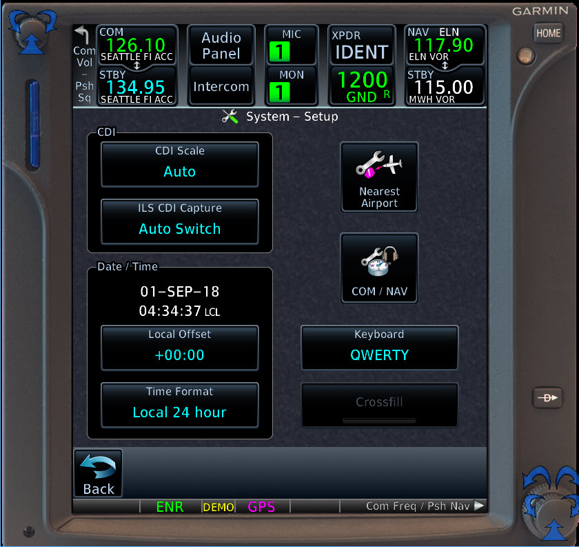
GTN750-Procedure-AirportInfoButton-02
QWERTY Keyboard

You can also choose a QWERTY keyboard instead of the alphabetical layout in previous versions of the GTN software. The option is available on the System Setup page.

GTN750-Qwerty-01
GTN750-Qwerty-02

IFR Lost Communications

All instrument pilots learn the rules (14 CFR §91.185) that apply if you lose two-way radio communications while operating under IFR. But most discussions of that regulation overlook three key paragraphs in the AIM and their practical implications.

DA40-IFR_0259a

Note: This original text for this post first appeared in the February 2018 issue of the American Bonanza Society magazine.

First, to review the basics, see 14 CFR §91.185 and the Instrument Flying Handbook (FAA H-8083-15B), which describes the details of the regulation in “Communication/Navigation System Malfunction” (p. 11-8).

14CFR91.185

To simplify matters, most of us employ a mnemonic such as Avenue F MEA to aid recall of the key details of the route and altitude to fly (assuming you are not flying in VMC, do not encounter VMC after losing two-way communications, and that you cannot hear or respond to ATC via voice over a navaid, squawking IDENT, turning to headings, or other means).

Avenue F (Route)

  • Assigned: Last assigned heading, or—
  • Vectored: Fly the last vector to the ATC-specified fix or route, or—
  • Expected: Fly the route ATC last told you to expect (e.g., join an airway, feeder route, localizer, etc.), or—
  • Filed: If you haven’t received an updated clearance or route from ATC, fly the route that you filed.

MEA (Altitude)

  • The minimum en-route altitude for the segment of the route you’re flying, or—
  • The expected altitude ATC told you to anticipate, or—
  • The assigned altitude that ATC included in your original clearance

To the route and altitude, add timing, so that you arrive at your intended destination when ATC is expecting you, per the details in the regulation and the AIM.

To these guidelines, I add the specific lost communications procedures that are typically included as notes for published IFR departure procedures. For example, see the chart for the YELM THREE departure at the Olympia, WA (KOLM) airport.

YELM-lostcomm
Practical Advice from the AIM

Instructors and DPEs enjoy posing lost-communications scenarios that require careful parsing of 14 CFR §91.185 and scrutiny of IFR charts.

AIMTitlePage.jpg

But in focusing on the regulation itself, we often overlook what is arguably the most important practical guidance for such situations, found in AIM 6−4−1: Two-way Radio Communications Failure.

The first three paragraphs of that section note that:

a. It is virtually impossible to provide regulations and procedures applicable to all possible situations associated with two-way radio communications failure. During two-way radio communications failure, when confronted by a situation not covered in the regulation, pilots are expected to exercise good judgment in whatever action they elect to take. Should the situation so dictate they should not be reluctant to use the emergency action contained in 14 CFR Section 91.3(b).

b. Whether two-way communications failure constitutes an emergency depends on the circumstances, and in any event, it is a determination made by the pilot. 14 CFR Section 91.3(b) authorizes a pilot to deviate from any rule in Subparts A and B to the extent required to meet an emergency.

c. In the event of two-way radio communications failure, ATC service will be provided on the basis that the pilot is operating in accordance with 14 CFR Section 91.185. A pilot experiencing two-way communications failure should (unless emergency authority is exercised) comply with 14 CFR Section 91.185….

Note also that the Instrument Rating ACS places lost communications procedures in section VII Emergency Operations. The standards for Task A in that section state that you must understand and demonstrate the:

Procedures to be followed in the event of lost communication during various phases of flight, including techniques for reestablishing communications, when it is acceptable to deviate from an IFR clearance, and when to begin an approach at the destination.

The AIM text recognizes and implicitly suggests several issues that you must consider if you lose two-way communications while operating IFR in IMC. For example:

  • What caused the communications failure? Just broken radios? A fault somewhere in the electrical system?
  • Will proceeding according to the regulation require you to continue the flight–perhaps for an extended time–over potentially hazardous terrain or through challenging weather?
  • Are you currently operating within or near busy airspace, such as Class B? Will your cleared IFR route take you near or into such airspace?

Suppose, for example, that you lose communications after you level off westbound following a departure from Spokane International Airport (KGEG) in Washington state en route to Boeing Field (KBFI) in Seattle.

KGEG-KBFI-IFRLow

Your clearance will take you via V2 across the Cascade Mountains to Boeing Field (KBFI) in Seattle. You are not on fire or aware of any other issue with the airplane that demands an immediate precautionary landing. Weather at airports along or near your route is IMC but at or above published minimums for the approaches available to you.

Adhering to the letter of 14 CFR §91.185 would require you to continue along your last cleared route at the appropriate altitudes to arrive as close as possible to your ETA at KBFI.

But the introductory paragraphs to AIM 6-4-1 give you broad support to exercise your emergency authority as PIC.

For example, diverting to an airport such as Moses Lake (KMWH) and flying one of its many available approaches would be far more reasonable than continuing across the mountains and then descending into the congested airspace that surrounds Seattle—and perhaps holding near KBFI to arrive near your ETA.

BANDR-KBFI.jpg

Whether or not you continue strictly according to the regulations, ATC will clear the airspace around you until your intentions are clear and they’re able track you or confirm that you’re on the ground. Assuming that they can still observe you—even if only as a primary target on their traffic displays—they will be happy to watch you descend into a relatively quiet airport like KMWH rather than, like members of a curling team, furiously sweep the path in front you all the way to your filed and cleared destination.

ForeFlight PDF Briefing Format

ForeFlight has added a PDF option for displaying preflight briefings. As the tweet below explains, the enhanced PDF briefing provides a more compact briefing that, among other features, sifts out irrelevant NOTAMs.

ForeFlight-PDF-Briefing-Tweet

The Briefing Format option is on the Settings tab in ForeFlight.

ForeFlight-BriefingFormat

I tested the feature by briefing an IFR flight from Boeing Field (KBFI) in Seattle to Felts Field (KSFF) in Spokane. You can download the full PDF of that briefing here.

The illustrations below show examples of the pages from the briefing.

ForeFlight-PDF-Briefing-P1

ForeFlight-PDF-Briefing-P2

ForeFlight-PDF-Briefing-P3

ForeFlight-PDF-Briefing-P4


FAA Proposes End to HIWAS

FAA is requesting comments on a proposal to discontinue the Hazardous Inflight Weather Advisory Service (HIWAS) provided by Flight Service.

For more information about changes to services provided by FSS, see the FAA website, here, and this item at BruceAir.

FAA announced the proposal in the Federal Register on July 23, 2018. Comments are due August 22, 2018; refer to Docket Number FAA-2018-0649.

Here’s the key text of the announcement:

Hazardous Inflight Weather Advisory Service (HIWAS) is a continuous broadcast of weather advisories over a limited nationwide network of VORs that provide pilots with meteorological information relating to hazardous weather. Since the early 1980s, the broadcast, available in various locations of the contiguous United States (CONUS) allows pilots to access hazardous weather while inflight without going through a Flight Service specialist. HIWAS was conceived when there was a large demand for inflight briefings from specialists and wait times could be extremely long. HIWAS alleviated the workload of the specialists and helped to reduce wait times for pilots. At that time, pilots had no other choice but to contact Flight Service to obtain hazardous weather updates for the route of flight. Originally created by specialists using scripts, HIWAS is now produced using text to voice technology.

With the advent of the internet and other technology, the demand for inflight services from Flight Service specialists has declined. Staffing was 3,000+ specialists in more than 300 facilities during the early 1980s and now consists of three hub facilities. In 2018, radio contacts dropped to less than 900 per day from an average of 10,000 radio contacts per day.

As part of FAA efforts to modernize and streamline service delivery, the agency is interested in receiving comments on elimination of the Hazardous Inflight Weather Advisory Service.